|
Location
|
Proxy
|
Reference
|
Dating method
|
Size of speleothem (cm)
|
Number of dating samples
|
Resolution
|
Age model type
|
Name of rock sample
|
Dated material
|
Proxy of
|
|
54
|
Actun Tunichil Muknal cave
|
δ18O
|
Frappier, 2002; Frappier et al., 2007
|
137Cs, layer counting
|
2.6
|
12
|
Sub-seasonal
|
Piecewise-linear model
|
ATM7
|
Organic material
|
ENSO, hurracanes
|
|
55
|
Box Tunich cave
|
δ18O
|
Akers et al., 2019
|
U-series, 14C, 210 Pb
|
9.3
|
9
|
8 years
|
Piecewise-linear model Chrono-logical Tunning
|
BZBT
|
Calcite, Organic Material
|
Palaeo-precipitation
|
|
56
|
Chaltun Ha sinkhole
|
Fluorescence
|
Frappier et al., 2014
|
layers counting
|
16.9
|
layers counting
|
Annual
|
Piecewise-linear model
|
CH-1
|
Calcite
|
Flooding events
|
|
57
|
Chan Hol cave
|
δ13C, δ18O
|
Stinnesbeck et al., 2017
|
U-series
|
7.2
|
17
|
Centennial
|
Piecewise-linear model
|
CH-7
|
Calcite
|
Palaeo-precipitation
|
|
58
|
Chen Ha cave
|
δ13C, δ18O
|
Pollock et al., 2016
|
U-series
|
100
|
11
|
Sub-annual
|
Linear interpolation model
|
CH04-02
|
Calcite
|
Palaeo-precipitation
|
|
59
|
Macal Chasm cave
|
δ18O,δ13C,
luminescence, reflectance
|
Akers et al., 2016; Webster et al., 2007
|
14C
|
93.6
|
16 of U-Th, 8 of 14C, 2 of 210Pb
|
Byannual TCP, 4 and 15 years modern, 20 years paleoindian and pre-classic
|
Piecewise-linear model, Bacon age-depth model
|
MC-01
|
Calcite
|
Palaeo-precipitation, cultivation and soil use
|
|
60
|
Naharon Sinkhole
|
δ13C, δ18O, Mg/Ca, Sr/Ca, Ba/Sr
|
Warken et al., 2021
|
U-series, 14C
|
11
|
18
|
Decadal
|
Piecewise-linear model
|
NAH14
|
Calcite
|
Palaeo-precipitation
|
|
61
|
Rey Marcos cave
|
δ18O
|
Winter et al., 2020
|
U-series
|
|
20
|
Decadal
|
COPRA
|
GU-RM1
|
Calcite
|
Palaeo-precipitation
|
|
62
|
Río Secreto cave
|
δ18O
|
Medina-Elizalde et al., 2016
|
U-series
|
31
|
13
|
8 years
|
Piecewise-linear model
|
Itzamna
|
Calcite
|
Palaeo-precipitation
|
|
63
|
Río Secreto cave
|
δ13C, δ18O, Mg/Ca, Sr/Ca
|
Serrato Marks et al., 2021
|
U-series
|
80
|
15
|
Annual
|
COPRA
|
RS1
|
Calcite
|
Palaeo-precipitation
|
|
64
|
Vaca Perdida cave
|
δ18O
|
Smyth et al., 2017, 2011, 2010
|
U-series
|
45
|
14
|
16.6 years
|
Piecewise-linear model
|
VP-10-1
|
Calcite
|
Palaeo-humidity
|
|
65
|
Yok Balum cave
|
δ13C
|
Ridley et al., 2015
|
cycles of δ13C, U-series
|
365
|
18
|
Monthly
|
Piecewise-linear model
|
Yok-G
|
Aragonite
|
Hurricanes
|
|
66
|
Yok Balum cave
|
δ18O
|
Kennett et al., 2012; Lechleitner et al., 2015; Maya et al., 2012
|
U-series
|
41.5
|
40
|
Subannual
|
Piecewise-linear model
|
Yok-1
|
Calcite
|
Palaeo-precipitation
|
|
67
|
Tzabnah cave
|
δ18O
|
Medina-Elizalde et al., 2010; Medina-Elizalde and Rohling, 2012
|
U-series and layers counting
|
44.1
|
12
|
2.3 years
|
Piecewise-linear model
|
Chaac
|
Calcite
|
Palaeo-humidity
|
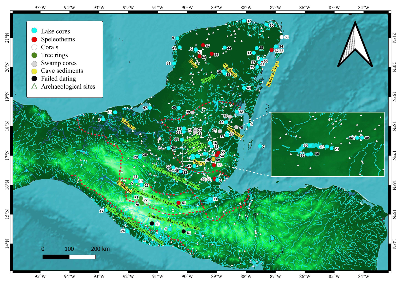
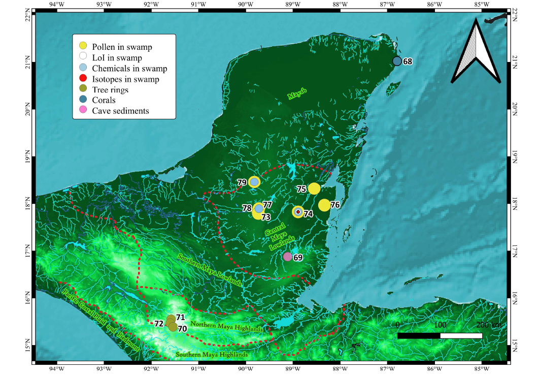
Figure 3. Location of studies that used speleothems as environmental records. The map also shows the spatial distribution of the proxies studied in each speleothem (see legend). The numbers indicate the name of the studied site listed in Table 3. Borders (red dotted lines) indicate the different sub-areas in the MA referred in Figure 1. Map produced using QuantumGIS 3.28.4.
ADDITIONAL RECORDS IN THE MA
The Punta Nizuc record (Table 4) is the only one based on studying corals (Horta-Puga and Carriquiry 2012), however it only covers a small recent period. Therefore, reef corals based records seem unsuitable for paleoclimatic reconstructions in the MA.
The only research that has used tree rings in the MA (Table 4) was performed in Puerta del Cielo, San Juan Mountain and Bosque del Rancho in the Southern Highlands in Guatemala (Figure 4, green circles). This small number of records is probably a consequence of several factors. First of all, there have been few studies on trees in the region because it has generally been assumed that trees in the lowland tropics do not form annual rings, unlike trees in higher-latitude or higher-altitude regions that cease growth completely in winter (Douglas et al., 2016a).
This idea is supported by the lack of a significant gradient of temperature between winter and summer; therefore, the rings reflect seasonal changes in precipitation. However, it has been shown that trees still produce rings at low latitudes. Besides, as in other parts of North America, the vegetation in the highlands is composed of the cloud forest of coniferous trees due to the high elevation that produces more temperate climates. The issue with the dendroclimatological records is not the lack of tree rings but the preservation of the old trees (Douglas et al., 2016a).
Second, it is unlikely that many living trees in the Maya area are older than a few hundred years (the same applies in general for tropical ecosystems), restricting the time frame over which climate variability in the region could be studied by this method (Douglas et al., 2016a). Therefore, the chance to find dendroclimatological records contemporary with the Mesoamerican periods is meagre.
The current stage of dendroclimatology research in the MA makes this kind of record unsuitable for reconstructing climates during the Mesoamerican periods. Some dendrochronological archives in the Cultural Archaeological Areas of Aridoamerica, (American Southwest) and the centre of Mesoamerica, evidently outside the MA, has been used to sustain the hypothesis of the Maya Droughts (Stahle et al., 2011). However, the location of these records makes them very problematic since they were exposed to different climate regimes. However, if the climate dynamics between them are known, linking the different areas might be possible.
The records based on sediment cores or discrete sediment samples from profiles from seasonal wetlands (e.g. sediments from archaeological profiles) used pollen as a proxy for vegetation, while three of them, Ramonal, Laberinto (Gunn et al., 2002) and Akab Muclil (Krause et al., 2019), used the elemental composition of the sediments. Akab Muclil is the only record to use an isotopic proxy, δ13Corganic (Table 4).
Most wetland records are located in the southern part of the Mayab near the Central Lowlands border (Figure 4 grey circles). Another unusual record in the MA is the one based on cave sediments at Ixchel Reflection Cave (Polk et al., 2007) (Figure 4 yellow circle) where δ13C was compared to a similar proxy in the speleothem of Macal Chasm (Webster et al., 2007), showing similar trends interpreted as variations of humid and dry conditions (Polk et al., 2007). Table 4 summarises the proxies used on these records.
TEMPORAL FRAMEWORK OF PALAEOCLIMATIC RECORDS IN THE MA
I developed a list of records spans in the MA. As the chronology of the lake sediment records is mainly based on radiocarbon dating. I created a list of the assigned age for the bottom and top points of the entire record extrapolated from the applied age model (I used the extreme assigned ages of this interval, instead of the median ages). The sources of material for dating are mentioned, as well as the number of dates obtained (Table 1). It is not mentioned if a record's age model used a hard water error correction since this step is not always described even in records with high carbonate content in karst areas. This issue is more commonly addressed in the records produced in the Mayab for the last 15 years, normally searching terrestrial material for dating, which is not influenced by old carbon.
The dating method used in the record is also shown (e.g., radiocarbon, U-series, layers counting, etc) (Tables 1–4). As well as age models, which were constructed by diverse algorithms by the authors of the respective research, including linear and polynomial regression, piecewise-linear models, and Bayesian statistics-based models, including those generated in CLAM or Bacon software. Many records attributed the date of the core collection to the top of the core without assuming any removal of material and a continuous sedimentation process. Many records attribute an age of 0 BP at the top even though the discrepancies between the year of collection and the assigned age 0 BP, (1950 AD) were not always negligible. Some records have no age model assigned, leaving the measured ages as a point of comparison besides the depth. Only some records had the opportunity to use an actual tephra layer of known provenance for dating, e.g. records at Guatemala, Tabasco and Campeche (Nooren, 2017; Stansell et al., 2020). Other dating methods used, such as 210Pb, are also specified in Table 1. The published radiocarbon dates were uncalibrated for the records published before the 1990s. Therefore, I calibrated these dates using the IntCal13 calibration Curve in OxCal, when it was possible. The year of coring, length of the record and spatial sampling interval of the proxy with most samples is also noted (Tables 1–4).
The sampling temporal resolution of the record was calculated using these two last parameters and the chronology assigned by the authors of every record, following the formula
(1)
where R is the obtained resolution, SD is the sampling distance of the proxy with most samples, Om is the oldest measured date, Ya is the assigned date at the top, Do is the depth of the oldest date. In this way, it was possible to establish which records have a resolution better than 20 years, which will be considered high resolution records (Figure 5, lines with a + sign). These high resolution records are important since they would have potentially registered events such as decadal droughts, ENSO signals, and even hurricanes (if the residence time is also lower than 20 years), which could be revelled using spectral analyses such as wavelets (Coutino et al., 2021; Lachniet et al., 2004; Medina-Elizalde et al., 2016a, 2016b; Nooren et al., 2018; Pollock et al., 2016; Serrato Marks et al., 2021) The variance analyses in high resolution records are also useful to test the residence time of the system (Pollock et al., 2016). The time frames covered by every palaeoenvironmental record in the MA is displayed first by groups (Figure 5, colour indicates the record type); the wetland records, lake sediment records, speleothems, cave sediments, corals and tree rings. And second by alphabetical order.
However, where records have longer chronologies, e.g. Chichancanab (Covich and Stuiver 1974), I constrained the period of the record to the time frame that has been studied using a group of proxies. Figure 5 also shows a dotted line for the major part of the period studied at Aguada X'Caamal, representing when this sinkhole functioned as an open system, making its studied proxy (δ18O) unreliable as a proxy of evaporation-precipitation ratio for that period (Hodell et al., 2005a). Some records share the same chronology, since one is stratigraphic correlated with the other instead to develop its own absolute chronology for instance, the records at Santa Ana La Vieja and Petenxil (Cowgill et al., 1966).
Most records cover only a part of the Holocene (Figure 5). Only 12 records cover the Greenlandian Stage. The number increases to 32 for the Northgrippian Stage, while the Meghalayan stage is the time frame that contains most records; 74.
The speleothem, coral and tree rings tend to have a better resolution than lake sediments. However, these records only cover a small fraction of the Holocene. The exception is the speleothem in the Rey Marcos cave, which covers all the Holocene (Winter et al., 2020). However, this record is in the highlands. In summary, despite the relatively large number of records, the MA still needs to have records that cover longer time frames, high resolution, and more of a multiproxy approach. In an alternative display of the time frame covered by the records by latitude, the central lowlands possess the major concentration of high resolution records, excluding the Peten region, followed by the Belize caves (Supplementary Material, Figure S2). Whilst the Pacific Coast does not have any high resolution record.
Table 4. Palaeoenvironmental records not based-on speleothems or lake sediments. The table also shows information related to the resolution of the proxies studied as well as the age model (dating method, age model type and dated material).
|
Num.
|
Location
|
Kind of Record
|
Reference
|
Dating method
|
Age model type
|
Dated material
|
Mean resolution (years)
|
|
68
|
Punta Nizuc Reef
|
Coral
|
Horta-Puga and Carriquirry, 2012
|
Layer counts
|
Linear regression
|
Coral
|
Annual
|
|
69
|
Ix Chel Reflection cave
|
Cave sediments
|
Polk et al., 2007
|
Radiocarbon
|
Piecewise-linear model
|
organic material
|
Centennial
|
|
70
|
Bosque del Rancho
|
Dendroclimatology
|
Anchukaitis et al., 2013
|
Crossdating
|
Piecewise-linear model
|
Trees
|
Annual
|
|
71
|
Puerta del cielo
|
Dendroclimatology
|
Anchukaitis et al., 2014
|
Crossdating
|
Piecewise-linear model
|
Trees
|
Annual
|
|
72
|
San Juan Mountain
|
Dendroclimatology
|
Anchukaitis et al., 2015
|
Crossdating
|
Piecewise-linear model
|
Trees
|
Annual
|
|
73
|
Aguada Mucal, Brisa Rservoir, Fidelia Reservoir, Little Tom Reservoir
|
Artificial reservoir
|
Lentz et al., 2022
|
Archeo-Stratigraphic correlation
|
Linear model
|
Organics
|
Decadal
|
|
74
|
Akab Muclil
|
Seasonal swamp
|
Krause et al., 1919
|
Radiocarbon
|
Piecewise-linear model
|
Organics
|
Centennial
|
|
75
|
Cob Swamp
|
Seasonal swamp
|
Pohl et al., 1996
|
Radiocarbon
|
No transformation
|
Organics
|
Centennial
|
|
76
|
Cobweb
|
Seasonal swamp
|
Jones et al., 1994
|
Radiocarbon
|
No transformation
|
Organics
|
Centennial
|
|
77
|
Laberinto
|
Seasonal swamp
|
Gunn et al., 2012
|
Radiocarbon
|
No transformation
|
Organics
|
Centennial
|
|
78
|
Infierno
|
Seasonal swamp
|
Castanet et al., 2022
|
Radiocarbon
|
No transformation
|
Organics
|
Centennial
|
|
79
|
Ramonal
|
Seasonal swamp
|
Gunn et al., 2002
|
Radiocarbon
|
No transformation
|
Organics
|
Centennial
|
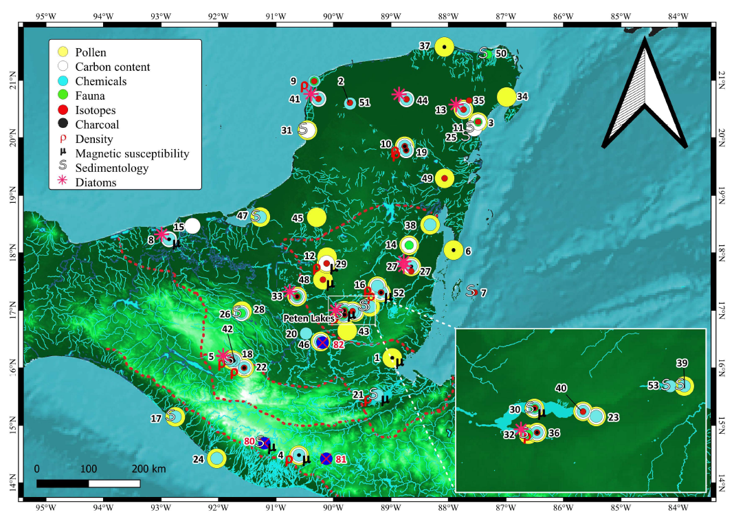
Figure 4. Location of studies that used swamp and wetland cores as well as tree rings, corals and cave sediments (see legend). The map shows the proxies used in every swamp record such as pollen, LoI, chemicals and stable isotopes (see legend). The numbers indicate the name of the studied site listed in Table 4. Borders (red dotted lines) indicate the different sub-areas in the MA referred in Figure 1. Map produced using QuantumGIS 3.28.4.
Figure 5. Time frame of the different records of the MA; temporal swamp (pink), lake (blue), speleothems (red), cave sediments (yellow), corals (black) and tree rings (green). Unpublished lake records are in pale blue. The letter indicates the critical periods during Maya History, the Maya Abandonment (A), the Maya Hiatus (H) and the Maya Collapse (C). The symbol (+) indicates the records with at least one proxy with a resolution better than 20 years. The numbers indicate the name of the studied site listed in Tables 1 to 4. Borders (red dotted lines) indicate the different sub-areas in the MA referred in Figure 1.
RELEVANT PALAEOCLIMATIC RECORDS OUTSIDE THE MA
The MA covers an extension of approximately 400000 km2. Therefore, the use of palaeoclimatic records outside this area to indicate the presence of a drought presents major challenges and is problematic from the epistemic point of view. The use of external palaeoclimatic records for supporting the Mayan drought is more complicated when they come from Southern Central America, e.g. the speleothem recovered at Chilibrillo Cave in eastern Panama (Lachniet et al.,2004) or central Mesoamerica, e.g. the speleothem collected at Juxtlahauca Cave (Lachniet et al., 2012) or Diablo Cave (Bernal et al., 2011), both in Guerrero. For example, the use of records in central Mesoamerica to support the Mayan drought hypothesis is problematic since they are immersed in different climates, although they are all in the same summer rainfall regime, so a shift in the overall drivers of this could give a coherent signal. For instance, substantial changes in settlement patterns also happened there at the time of the Maya Collapse at the end of the Mesoamerican Classic Period (Carrasco 2001; González-José et al., 2007).
Most of the palaeoclimatic records in central Mesoamerica indeed register recurrent droughts through the Mesoamerican periods, but they are not linked to societal Collapse on the same scale that occurred in the MA. The drought is not seen as a driver of the societal Collapse in central Mesoamerica, although it has been established that drought played a role to some degree in the decline of Teotihuacan as a major power, one of the most populated cities in the world at that time (Lachniet et al., 2017).
The use of palaeoclimatic records outside the MA for supporting the drought hypothesis is only justified if the drought was a manifestation of a climate event of planetary or transoceanic proportions. The fact that a series of civilisations in north-western South America presented a collapse, e.g. the Mochica Tiwanaku culture at a similar time around 1000 BP (deMenocal 2001), supports the idea of a subplanetary climate event. The end of the Tang dynasty in imperial China due to a decrease in the intensity of summer monsoons at the time of the Maya Classic Collapse could be connected to the same climatic event, (Yancheva et al., 2007).
The most accepted explanation of a climatic event of subplanetary proportions, which could have caused droughts in parts of Mexico, Central America, the northern part of South America and over China, is the displacement of the Intertropical convergence zone. Related to this, the most cited record outside the MA presented linked to the droughts during the Maya Collapse at the Terminal Mesoamerican Classic period is the titanium record of the marine sediments collected from the Cariaco basin of the coast of Venezuela (Haug et al., 2001, 2003). The titanium content through the record is a proxy of the displacement of the Intertropical Convergence, Zone, ITCZ. Since the movement of the ITCZ responds to solar insolation in a similar way that the Bermuda High, a displacement to the south of the highest north latitude position of the ITCZ might have coincided with a displacement to the south of the Bermuda High, causing drier trade winds over the MA. The Cariaco record is frequently used to compare with local studies in the MA for distinguishing between regional patterns and sub-planetary patterns of the hydrological balance despite its considerable distance from the Maya area and lack of correlation in modern climatology.
PRESENCE OF DROUGHTS IN THE TIME OF THE MAYA ABANDONMENT
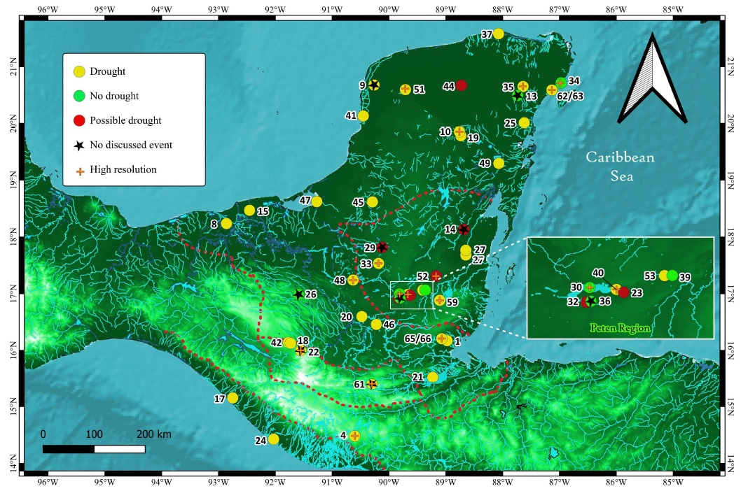
The spatial distribution of the 57 palaeoclimatic records that cover the period of the Maya Abandonment at the end of the Preclassic Mesoamerican period, shows the records that register an event associated to a dry event (a drought registered in a proxy related to rainfall, a change to drier forest or a change in vegetation that cannot be explained by anthropogenic forcing, or changes in the precipitation of secondary carbonates or evaporites) (Figure 6).
There are also records that possibly suggest a drought event (Figure 6). For example, this is the case at Lake Sayucil, Laguna de Cocos, Macanche and Petenxil, where at least one proxy related to rainfall or anthropogenic activity suggests a drought or/and lack of anthropogenic activity, respectively (e.g. no presence of Zea mays). The problem with these records is their lack of resolution. For instance, the pollen record at Lake Yaloch did not record any Zea mays and has a decrease in Poaceae, but such crops reappear after the period of the Maya Hiatus, indicating that the region was not abandoned at all or re-occupied (Wahl et al., 2013). The asterisk symbol indicates that the existence or possible existence of a dry event appears in the record but is not discussed by the authors.
Records that do not signal a drought are found in the central Lowlands of the Peten region (Figure 6). Naja is the only record that does not present a drought signal in the inland area (Domínguez-Vázquez and Islebe, 2008), but this is possible to the sampling resolution in its pollen record. In contrast, most records show a dry climatic signal at the Maya Abandonment, including records in the highlands, e.g. Lakes San Lorenzo and Esmeralda in Chiapas (Franco-Gaviria et al., 2018, 2020), Lake Kail (Stansell et al., 2020) or Lake Amatitlán (Velez et al., 2011), while all the speleothems in Belize and the Mayab indicate a very dry period.
Most high resolution records (14 of 17), which concentrate in the Riviera Maya and the Central Lowlands (Figure 6, plus sign) support the presence of a drought for the Maya Abandonment, the exception are the records at Peten Itza, Petenxil, Sacnab, Naja and Puerto Morelos.
Despite the resolution and approach, most records point out the presence of a dry period during the Maya Abandonment. In the works around El Mirador and Nakbe, Dahlin found evidence of habitation of seasonal swamps around 1800 BP (Dahlin, 1990) supporting this. The presence of records without drought signals in the Peten might be explained by the great amount of hydric sources in this area. However, the archaeological evidence infers that the population levels were truncated in this area, and population around the lakes maintained a smooth development (Gill, 2000). Another aspect to consider is the size and depth of the Peten Lake, as well as its connection with tributary rivers. This has an impact on the residence time which modulates the length of the signal that can be extracted. In this way, even if the sampling resolution of geochemical or isotopes proxies were annual, no major changes could be traced if the residence time of the lake studied is 10 or even 100 years (Leng and Marshall 2004). Even so, some records like the Ca/Ti, Fe and Al of Peten point out a tendency to dry conditions around this period (Mueller et al., 2009). But more research is needed according to the authors. At the centennial scale, climate has been the major driver of vegetation change according to the Peten Itza records (Correa-Metrio et al., 2012; Hodell et al., 2008), this might suggest that records based of pollen where changes of vegetation have been only linked to anthropogenic activities in this period might be associated in an important part to climatic changes. The presence of unequivocally proxies of dry conditions both in the highlands and the lowlands support this last interpretation.
Unfortunately, the Maya abandonment would require more research in Preclassic sites for comparing previous levels of population and the use of natural resources before the Maya Abandonment. This period has been less studied since many of the research in the southern lowlands, which contain most of the Preclassic Maya sites, is financially supported by the New World Archaeological Foundation, which by religious beliefs tends to avoid the study of the early Preclassic period. The new research at Aguada Fenix in the flood plains of Tabasco (Inomata et al., 2020) probably will bring light to the environmental history of this time.
Figure 6. Spatial distribution of the environmental signal at the moment of the Maya Abandonment. The records indicating a possible drought are not conclusive and have an insufficient temporal sampling resolution for observing decanal variations. The asterisk indicates that a stressful climatic event is observed in the record, but the authors do not discuss it. Records with a resolution better than 20 years are indicated (+). The numbers indicate the name of the studied site listed in Tables 1 to 4. Borders indicate the different sub-areas in the MA referred in Figure 1. Map produced using QuantumGIS 3.28.4.
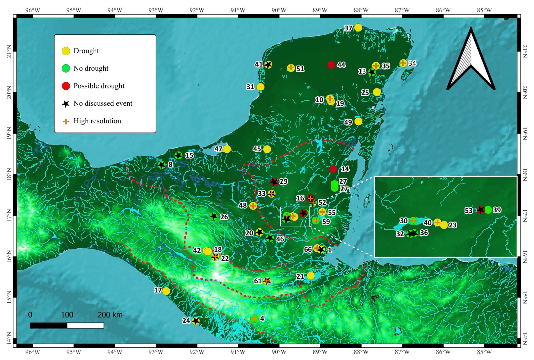
PRESENCE OF DROUGHTS IN THE TIME OF THE MAYA HIATUS
The spatial distribution of the 60 palaeoclimatic records at the moment of the Maya Hiatus according to the presence or absence of a drought, shows that most sites without signals of droughts are in the southern and central lowlands (Figure 7), including records at Lamanai and the stalagmite of Macal Chasm. Paradoxically, the concept of the Maya Hiatus was conceived based on the story of monuments and stelae constructions at Tikal (Drew, 2015; Moholy-Nagy, 2003), which was a big city in this region. Records in the Northern Mayab near the Caribbean Sea and near the flood lands of Tabasco near the Gulf of Mexico also do not show signals of a drought. This supports the idea that these two regions have more hydric resources than the MA which make them more resilient. It has to be highlight that some signals of drought are also associated to human agency such as the vegetation change in the pollen of Chumpich (Islebe et al., 2022; Torrescano-Valle et al., 2019).
The map also includes the records where the signal is ambiguous but could indicate a possible drought, e.g. Sayucil δ18O (Whitmore et al., 1996) or the interruption of the anthropogenic impact on the lake, e.g. Laguna de Cocos (Bradbury et al., 1990), and Lake Yaxha (Brenner, 1983). Almost all speleothems growing at this period suggest a drought at the moment of the Maya Hiatus, except for Macal Chasm (Akers et al., 2016). This indicates that the lack of drought signals in the central lowlands records is not always related to the lack of high resolution in records, since stalagmites in the MA have similar resolution. However, the epikarst at Macal Chasm could have a major residence time, cushioning a drought signal. This mechanism is unlikely due to the permeability of the epikarst in the MA, long residence times in karst system have not been reported until now. Despite Macal Chasm, the only high resolution records (Figure 7, plus sign) that do not register a drought during the Maya Hiatus are at Peten Itza and Yaloch. Fewer lake records show the presence of droughts during the Hiatus in comparison to the abandonment and the collapse periods, which might suggest that the drought was less intense than those in the other two periods, which agrees with the observations in the stalagmites at Yok Balum (Kennett et al., 2012) and Box Tunich (Akers et al., 2019). Another interesting point is the presence of droughts at the Highlands except for the record at Amatitlán (Velez et al., 2011). The asterisk symbol again indicates that a signal of drought appears in the record but is not discussed by the authors.
The absence of drought signal in many of the records around Tikal, where this concept was developed, indicates that the cultural hiatus at Tikal was not direct driven by droughts. However, the presence of droughts in other regions of the MA could have had an impact on the trade networks from which Tikal depended. For example, the Maya Hiatus marks the end of the human impact on Lake San Lorenzo in the highlands according to the human impact index reconstructed from its pollen record (Franco-Gaviria et al., 2018), even though the archaeological record suggests an occupation of the surroundings (e.g., at Chinkultic) until the Postclassic period (Navarrete, 2007). This might suggest that the lower human impact was a consequence of the disruption of the trade networks, where Chinkultic might have provided crops and wood to other regions.
Finally, the eruption of the volcano El Llapango in El Salvador in 1414 years BP is the most probable driver of the drought (Demarest, 2004). This dated eruption supports the presence of a drought event in the MA. Therefore, the cultural hiatus might have been only a local cultural phenomenon at Tikal, but in terms of the environmental history, it was a climate event that affected many zones of the MA.
Figure 7. Spatial distribution of the environmental signal at the moment of the Maya Hiatus. The records indicating a possible drought are not conclusive and have an insufficient temporal sampling resolution for observing decanal variations. The asterisk indicates that a stressful climatic event is observed in the record, but the authors do not discuss it. Records with a resolution better than 20 years are indicated (+). The numbers indicate the name of the studied site listed in Tables 1 to 4. Borders indicate the different sub-areas in the MA referred in Figure 1. Map produced using QuantumGIS 3.28.4.
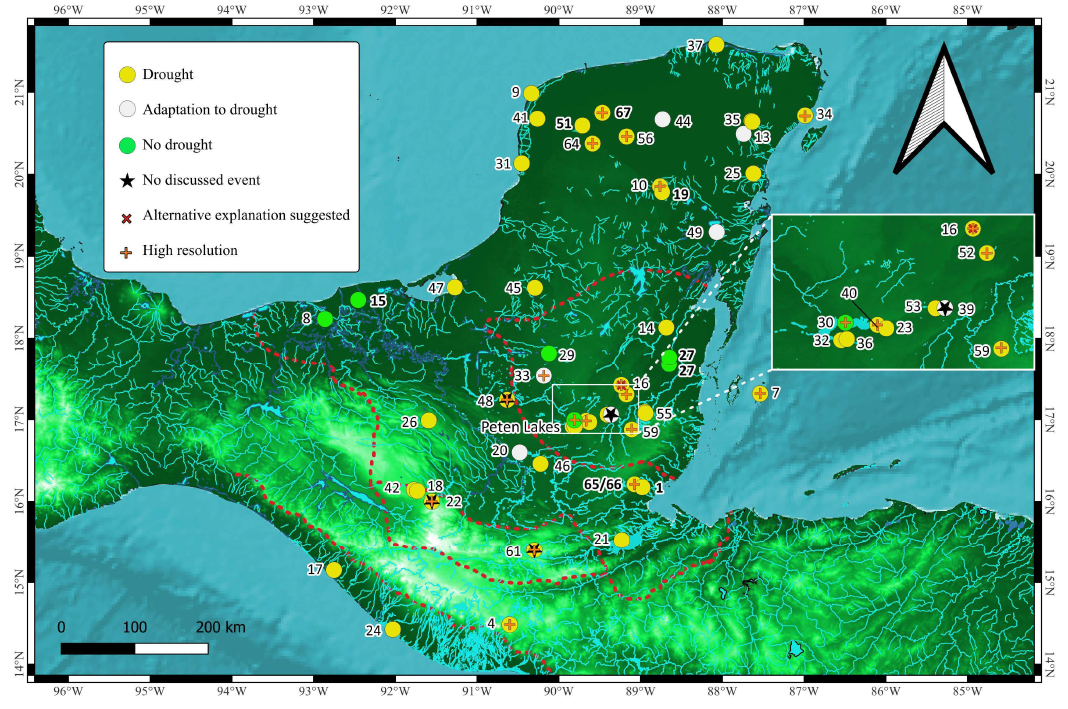
PRESENCE OF DROUGHTS IN THE TIME OF THE MAYA COLLAPSE
The spatial distribution of the 61 palaeoclimatic records based on speleothems and lake sediments that cover the period of the Maya Collapse at the end of the Classic Mesoamerican Archaeological period (Figure 8) shows six records without a signal related to a drought or a change of vegetation again concentrated in the central lowlands; Peten lakes (Cowgill et al.,1966, Leyden et al., 1993, Mueller et al., 2009, Schüpbach et al., 2015, Vaughan et al.,1985), Paixban (Wahl et al., 2016), the region of Lamanai (Metcalfe et al., 2009) and in the southern lowlands in the flood plains of Tabasco; Cometa and Cantemual
(Nooren, 2017). This is explained by the vast amount of hydric resources of these regions. In contrast, twenty-nine records recognise a drought event or a vegetation change. According to this, the drought effects not only happened at the lowlands, contrary to what has been argued but also in the highlands, where the impact was important.
Again, the asterisk indicates an apparent dry event in the record that is not discussed. This is the case of the record of Tuspan, whose chronology ends at the moment of the Collapse (Fleury et al., 2015).
Other than a pollen-based record, the other records that show a drought is based on a tendency to relatively high values in the δ18O, significant precipitation of evaporates, or changes in sedimentation rate. Most speleothems in the lowlands indicate a dry period between 1140 to 1040 BP (810 – 910 years A.D.), therefore the drought started around a half-century after the first step of the Collapse, the invasion of Tikal over Calakmul (Grube and Schubert 2015).
If the droughts were not the primary drivers of the Collapse, the insights provided by the 33 records, including 16 high resolution (Figure 8, plus sign), indicate that the drought existed during the Maya Collapse and may, therefore, have played a role in it. However, at the same time, the existence of records that do not show any signal related to a drought indicates that regional variables were able to cushion the effect of a drought (which depends on the sensitivity of the system). Another separate issue is if the drying was sufficient to disrupt agricultural and other human activities, from which some particular proxies depends (e.g. charcoal production, pollen, sedimentation rate).
There are also records where a proxy marks the existence of a drought, but the pollen record does not indicate changes in vegetation (Figure 8). For example, in the lake sediment record of Coba, physical proxies indicate lower lake levels and an increase in salinity, suggesting a drought. However, the pollen record indicates a presence of Zea mays during and after the Collapse during the Terminal Classic Mesoamerican period (Leyden et al., 1998; Whitmore et al., 1996). Thus perseverance of Zea mays is congruent with the archaeological and historical record that shows that the city of Coba did not collapse. Dry conditions might have offered favourable conditions for agriculture of Zea mays in subareas of the MA that used to suffer severe floods, e.g. Puerto Arturo (Wahl et al., 2014). However, this was not the case around Coba (Leyden et al., 1993). Thus, the perseverance of Zea mays here might suggest an adaptation to the droughts. The record in Lake Itzan also suggest a drought, but its proxy based on stanol also shows that humans activity continue (with a diminished population) even though the archaeological record suggests a complete abandon of the near sites (Keenan et al., 2021).
In the MA, changes in the vegetation are commonly linked to anthropogenic activity besides climate change, since agriculture promotes the clearance of extensive hectares of forest, the introduction of species like Zea mays (e.g. Carrillo-Bastos et al., 2010; Wright et al., 1996) or proliferation of the genus Cucurbita or Poaceae (e.g. Aragón-Moreno et al., 2012; Gutiérrez-Ayala et al., 2012; Kennett and Beach, 2013; Pohl et al., 1996), or the diminishing of some particular kind of forest for obtaining wood (Franco-Gaviria et al., 2018). Therefore, the interpretation of changes in the vegetation surrounding a lake has to be undertaken very carefully, and it has to be supported by additional proxies.
There are perhaps more palaeoclimatic records with signals for the Maya Collapse than other periods because the purpose of many studies in the MA focused on this issue. High resolution records indicate at least three severe droughts during the Collapse (Evans et al., 2018), sometimes intercalated with periods of floods (Smyth et al., 2017). According to Hodell et al., (1995) and Webster et al., (2007), these three drought events happened at 1140, 1090 and 1028 years BP based on lake sediments from Chichancanab in the Mayab or 1196–1152, 1079 and 1057–1028 years BP according to the speleothem from the Macal Chasm, at the Central Maya Lowlands (discrepancies fall inside the uncertainty of the age models used in the different records).
The diverse results show that the intensity of the droughts varied across the MA according mainly to the presence of hydric resources, the altitude and probably the interaction between the ITCZ, the trade winds and the high Bermuda High pressure system in Summer and the Nortes in Winter, which influence zones might have been diverse, complexed and different from what it has been seen in the instrumental epoch. In this way, Evans et al., (2018) inferred a reduction up to 47 % of rainfall compared to the present amount based on oxygen isotopes of gypsum in Chichancanab, whilst Medina-Elizalde et al., (2010) calculated a decrease of precipitation up to 35 % during the most severe dry periods at 1125 BP and 1020 BP based on the oxygen isotopes in the stalagmite at Tzabnah. However, the reduction of rainfall over Palenque would have never made water scarce in the Maya Southern Lowlands (Beach et al., 2008; Iannone 2014; Harrison 1993), but none calculation has been performed for these areas.
The geographic perspective of the signals related to droughts for the Maya Collapse suggest a quasi-ubiquitous decrease of the precipitation in the MA, where the absence of drought signals in some regions just means that locally its effect was negligible. The geographic perspective highlights that many of the immigration areas during the Collapse such as the Puuc Region (Grube and Schubert, 2015) and the Cochuah Region (Shaw, 2015), where Chichancanab is located, presented also signals of severe droughts. These areas were not particularly more attractive in terms of hydric resources than the emigration zones such as those around the Usumacinta River or the Central Lowlands (Demarest, 2014; Webster, 2002), which in contrast contain records pointing out that the effects of the droughts were imperceptible there. This contradiction between cities that were abandoned whilst other cities thrived during the collapse in rich and poor of hydric resources areas, respectively, and the intensity of the droughts indicates that we still do not know how critical the droughts were for changes in vegetation (and perhaps vice versa), how critical were for the quality of water (Waters et al., 2021), and how these changes impacted the human life (Douglas et al., 2016a). In addition, there are only a few studies of human bones, and too few animal bone and shell records for assessing a critical impact of droughts on humans and wildlife at the time of the Maya Collapse (Beach et al., 2015) and few studies involve the availability of food plant sources during the droughts (Fedick and Santiago 2022). Douglas et al., (2016a) suggest that more research about regional changes in soils would help to clarify the resilience to the droughts, but the lack of resolution of these archives does not seem sufficient for this.
In this way, the geomorphology variables, including the distribution of the superficial water bodies and the access to groundwater, as well as the patterns of the winds and rainfall in summer and winter still need to be reconstructed using GIS and climatic models such as PHYDA for having a better regional perspective. In addition, the socio-dynamics of the Maya communities needs more aspects to be investigated to have a better picture of the drivers of the migrations, that determined the abandon and thriving of the sites, including the available technology to keeping water for long periods. Until now the geographic perspective indicates whereas a water decrease was indeed present for the Collapse that is not enough to explain the settlement patterns during these times. An interested environmental hypothesis for explaining this contradiction is the possible increase of Saharan Dust to the Mayab due to the droughts, which trajectory nowadays covers the Mayab (Kutralam-Muniasamy et al., 2021; Liu et al., 2008), where the Tikul Hills (Puuc Region) would have been the first barrier to catch the dust. This might have provided nutrients to the soils, as it does in the Amazonas (Goudie and Middleton 2001; Nogueira et al., 2021; Swap et al., 1992), making the Puuc and Cochua regions more attractive for agriculture. In addition, another hypothesis based on the studies on L. Amatitlán in the Maya highlands explores a possible a shift in agriculture practices and/or the construction of channels in response to the droughts which might have been impacted the quality of water caused by the presence of cyanotoxin in water bodies due to the proliferation of cyanobacterias (Waters et al., 2021). This hypothesis is congruent with the observations of low-quality water in sites at the lowlands such as Tikal (Lentz et al., 2020), three rivers regions (Luzzadder-Beach and Beach, 2008), and L. Sayucil (Whitmore et al., 1996). Therefore, this might explain the abandon of areas rich in hydric sources.
Figure 8. Spatial distribution of the environmental signal at the moment of the Maya Collapse. The records indicating a possible drought are not conclusive and have an insufficient temporal sampling resolution for observing decanal variations. The asterisk indicates that a stressful climatic event is observed in the record, but the authors do not discuss it. The label "Adaptation to droughts" indicates sites where the physical proxies indicate the presence of droughts, but the pollen record does not show a change in vegetation, including the preservation of crops like Z. mays. Records with a resolution better than 20 years are indicated (+). The numbers indicate the name of the studied site listed in Tables 1 to 4. Borders indicate the different sub-areas in the MA referred in Figure 1. Map produced using QuantumGIS 3.28.4.
PROBLEMS OF THE RECORDS TO RECONSTRUCT THE ENVIRONMENTAL HISTORY OF THE MA
The comparison between records presents two major problems. For one side the synchronism of the signals between records is questionable, since age models were dated by different methods, and the uncertainties deepens not only of this but in the amount of absolute dates studied. On the other side, each record contains proxies which ability to trace climate changes depends on the sampling resolution and the residence time of the analyte in the system. Because these reasons, it is important to eliminate the uncertainties that exist between records, which might make their climatic signals difficult to compare. If it is possible, the method developed by Breitenbach et al., (2012) for developing age models can be applied to old and new records to homologate and make the climatic signals between records synchronic in terms of dating, making them comparable for tracing short temporal signals. Despite these problems, the geographic perspective showing the presence or absence of signals related to droughts in a particular time frame and emphasising which records are high resolution, is still valid.
FINAL COMMENTS
Although 82 records have been produced for the MA, this paper shows that as Beach et al., (2015), Aimers and Hodell, (2011), and Douglas et al., (2016a) suggest it is still necessary new high-resolution, multiproxy, accurately dated records. This new research must involve the development of proxies such as the stanol for the human impact, pigments for the quality of water and chemical ratios that help to understand the presence of aerosols either volcanic ash or Saharan dust. Yancheva et al., (2007) highlighted that the droughts in the MA were a manifestation of a planetary climatic event, therefore their duration was the same in the MA, even though their effects in terms of intensity were perceived different in every subregion.
The new records must have components that help to separate the anthropogenic signals from the natural climate signals, if it is possible. They must reach the same highest sampling resolution, equalizing the time frame covered by the environmental signal according to the residence time of the system. These records must feed data for mathematical models (Douglas et al., 2016a) such as those in PHYDA, that can take in consideration volcanic eruptions, aerosols (such as the Sahara Dust and wildfires) and insolation (Baek et al., 2019; Steiger et al., 2018; Tejedor et al., 2021b,a). Until now, mathematical models have been constrained to hydroclimatic variables (Collard et al., 2021) and tend to constrain big areas that do not allow the details of the resilience between subregions in the MA (Bhattacharya and Coats 2020; Bhattacharya et al., 2017).
In contrast, many theoretical models incorporating climatic patterns tend to be geographic comparison between climatic records or logic diagrams between variables showing loops and feedbacks, but no computational models. In this way, archaeological and soil data is added to these models, pointing out the contradictions between them, when deterministic causation cannot be appealed. Most of these models are constrained to localities (Dahlin, 2002; Kennett et al., 2022; Prufer et al., 2022). Some of them are constrained for the Mayab (Hodell et al., 2007), the lowlands (Bhattacharya et al., 2022; Douglas et al., 2015, 2016b; Gill et al., 2007; Kennett et al., 2012; Lucero et al., 2011; Me-Bar and Valdez, 2003), or the high lands (Harvey et al., 2021). But none has been performed for the hole MA. Many of these models tend to forget the human agency. Until now, most of the papers that incorporate an environmental explanation (droughts or soil depletion) of the abandonment, hiatus or collapse in regional terms have not included mathematical models, or over interpreted the archaeological finds or added western conceptions. For example, warfare has been argued for the collapse as a result of the droughts, although the archaeological record, despite epigraphy has not found signs of warfare.
CONCLUSIONS
This paper has presented a summary of the 82 palaeoclimatic records in the MA. The spatial and temporal areas covered by records and their proxies have been presented graphically, highlighting the distribution of high resolution records and the information gaps related to the scarcity of records or the lack of proxies in some areas. Most of the records (74) covered the late Holocene, in contrast less of the half (32) cover the Middle Holocene and only a few (12) cover the Early Holocene. The speleothem at Rey Marcos and the records at Peten Itza are the only two records that constrain the hole Holocene. Although the record a Quexil encompasses also the all Holocene, it is a low resolution pollen record with not good quality on dating. This summary can help to plan new research in the MA.
The mayor environmental results of the records available were compared to test the hypothesis of the mega-droughts proposed by Gill (2000), presenting a spatial distribution of the signals associated to droughts for the Maya Abandonment, the Maya Hiatus, and the Maya Collapse. The spatial distribution supports the idea that these historical events are linked to dry regional environmental conditions. However, the intensity of the dry conditions was different in specific areas, and some of these areas might have had specific conditions to cushion the dry conditions. The Maya Central Lowlands had more hydric resources to cushion dry events during the three critical historical events. The drought presented for the Maya Hiatus was the less intense dry period based on the number of records that present drought signals.
The geographic perspective indicates a decrease of water incoming during the Maya Abandonment. The geographic perspective also highlights that a dry regime existed during the Maya Hiatus in most part of the MA, but not in the Central Lowlands where this cultural phenomenon was identified. This indicates that the Maya Hiatus was not triggered by the climate conditions in the central lowlands. But the dry conditions in other areas of the MA might have played a role in its cultural Hiatus.
The geographic perspective indicates that dry conditions indeed existed in all the MA during the time of collapse. However, the cities that collapsed were in areas where the climate records indicate negligible dry conditions due to the vast amount of water sources (regions such as the Peten lakes, Belize and the flood plains of Tabasco). In contrast, regions, that suffered a strong decreasing of rainfall in the Mayab, such as the Puuc or Cochuah regions, thrived. This contradiction between the collapse and flourishment of Maya cites and the cushioned and severe droughts indicates that the droughts were not the only important environmental factor in the abandon and migration phenomena presented during the Collapse. Factors such as the productivity of soils and the quality of water might have been also played a role.
Finally, more high-resolution records with a multi-proxy approach covering most of the Holocene, and a synchronous dating are needed to generate mathematical models, that can help to understand better the environmental and climate change in different zones of the MA.
SUPPLEMENTARY MATERIAL
Figures S1 and S2 can be downloaded at <www.rmcg.unam.mx> in the abstract's preview page of this paper.
ACKNOWLEDGEMENTS
I thank the CONACYT for the studentship 440756 and the postdoctoral grant Elisa Acuña in UNAM 2023. I also want to recognise the help provided by Dr. Alan Covich (University of Georgia), Prof. Eberhard Gischler (University of Frankfurt), Dr. Holger Weissenberg and MSc. Emmanuel Valencia (Colegio de la Frontera Sur), Dr. Philip van Beyen (University of South Florida), Prof. Mark Brenner (University of Florida), answering some questions. Thanks to Dr. Berenice Solis Castillo for her help in soil topics. A special acknowledgment to Prof . Sarah E. Metcalfe and Prof. Matthew D. Jones (University of Nottingham) for their advice and suggestions during the preparation of this paper.
REFERENCES
Aimers, J., Hodell, D., 2011, Drought and the Maya: Nature, 479, 44-45, https://doi.org/10.1038/479044a.
Akers, P.D., Brook, G.A., Railsback, L.B., Cherkinksy, A., Liang, F., Ebert, C.E., Hoggarth, J.A., Awe, J.J., Cheng, H., Edwards, R.L., 2019, Integrating U-Th, 14C, and 210Pb methods to produce a chronologically reliable isotope record for the Belize River Valley Maya from a low-uranium stalagmite: The Holocene, 29(7), 1234-1248, https://doi.org/10.1177/0959683619838047.
Akers, P.D., Brook, G.A., Railsback, L.B., Liang, F., Iannone, G., Webster, J.W., Reeder, P.P., Cheng H., Edwards, R.L., 2016, An extended and higher-resolution record of climate and land use from stalagmite MC01 from Macal Chasm, Belize, revealing connections between major dry events, overall climate variability, and Maya sociopolitical changes: Palaeogeography, Palaeoclimatology, Palaeoecology, 459, 268-288, https://doi.org/10.1016/j.palaeo.2016.07.007.
Anchukaitis, K.J., Taylor, M.J., Martin-Fernandez, J., Pons, D., Dell, M., Chopp, C., Castellanos, E.J, 2013, Annual chronology and climate response in Abies guatemalensis Rehder (Pinaceae) in Central America: Holocene, 23(2), 270-277.
Andersen, M.B., Stirling, C.H., Potter, E.K., Halliday, A.N., 2004, Toward epsilon levels of measurement precision on 234U/238U by using MC-ICPMS: International Journal of Mass Spectrometry, 237(2-3), 107-118
Anselmetti, F.S., Hodell, D.A., Ariztequi, D., Brenner, M., Rosenmeier, M.F., 2007, Quantification of soil erosion rates related to ancient Maya deforestation: Geology, 35(10), 915-918.
Aragón-Moreno, A.A., Islebe, G.A., Torrescano-Valle, N., 2012, A ~3800-yr, high-resolution record of vegetation and climate change on the north coast of the Yucatan Peninsula: Review of Palaeobotany and Palynology, 178, 35-42, https://doi.org/10.1016/j.revpalbo.2012.04.002.
Aragón-Moreno, A.A., Islebe, G.A., Torrescano-Valle, N., Arellano-Verdejo, J., 2018, Middle and late Holocene mangrove dynamics of the Yucatan Peninsula , Mexico: Journal of South American Earth Sciences, 85(May), 307-311.
Baek, S.H., Steiger, N.J., Smerdon, J.E., Seager, R., 2019, Oceanic Drivers of Widespread Summer Droughts in the United States Over the Common Era: Geophysical Research Letters, 46(14), 8271-8280.
Beach, T., Dunning, N., Luzzadder-Beach, S., Cook, D.E., Lohse, J., 2006, Impacts of the ancient Maya on soils and soil erosion in the central Maya Lowlands: Catena, 65(2), 166-178.
Beach, T., Luzzadder-Beach, S., Cook, D., Dunning, N., Kennett, D.J., Krause, S., Terry R., Trein, D., Valdez, F., 2015, Ancient Maya impacts on the Earth’s surface: An Early Anthropocene analog?: Quaternary Science Reviews, 124, 1-30, https://doi.org/10.1016/j.quascirev.2015.05.028.
Beach. T., Luzzadder-Beach, S., Dunning, N., Cook, D., 2008, Human and natural impacts on fluvial and karst depressions of the Maya Lowlands: Geomorphology, 101(1-2), 308-331.
Bermingham, A., Whitney, B.S., Loughlin, N.J.D., Hoggarth, J.A., 2021, Island resource exploitation by the ancient Maya during periods of climate stress, Ambergris Caye, Belize: Journal of Archaeological Science: Reports, 37(May), 103000, https://doi.org/10.1016/j.jasrep.2021.103000.
Bernal, J.P., Eggleton, R,A., McCulloch, M.T., 2006, U-series analysis of weathering minerals by LA-MC-ICP-MS: a new tool for regolith geochronology, in Pillans, B. B. (ed.), Regolith Geochronology and Landscape Evolution, Open File Report 189: Canberra, Australia, Cooperative Research Centre for Landscapes, Environment and Mineral Exploration, 27-41.
Bernal, J.P., Beramendi Orosco, L.E., Lugo-Ibarra, K.C., Daesslé, L.W., 2010, Revisión a algunos geocronómetros radiométricos aplicables al Cuaternario: Boletín de la Sociedad Geológica Mexicana, 62(3), 305-323
Bernal, J.P., Lachniet, M., McCulloch, M., Mortimer, G., Morales, P., Cienfuegos, E., 2011, A speleothem record of Holocene climate variability from southwestern Mexico: Quaternary Research, 75(1), 104-113.
Bhattacharya, T., Chiang.J.C.H., Cheng, W., 2017, Ocean-atmosphere dynamics linked to 800 e 1050 CE drying in Mesoamerica: Quaternary Science Reviews, 169, 263-277.
Bhattacharya, T., Coats, S., 2020, Atlantic-Pacific Gradients Drive Last Millennium Hydroclimate Variability in Mesoamerica: Geophysical Research Letters, 47(13), 1-12.
Bhattacharya, T., Krause, S., Penny, D., Wahl, D., 2022, Progress report: Drought and water management in ancient Maya society: Progress in Physical Geography, 0(0), 1-16.
Braadbaart, F., Poole, I., van Brussel, A, A., 2009, Preservation potential of charcoal in alkaline environments: an experimental approach and implications for the archaeological record: Journal of Archaeological Science, 36(8), 1672-1679.
Bradbury, J,P., Forester, R, M., Bryant, W,A., Covich.A, P., 1990, Paleolimnology of Laguna de Cocos, Albion island, Rio Hondo, Belize, In Pohl, M.D., Ancient Maya Wetland Agriculture: Excavations on Albion Island, Northern Belize: Westview Press Boulder, 119-154.
Breitenbach, S, F, M., Rehfeld, K., Goswami, B., Baldini, J, U, L., Ridley, H, E., Kennett, D, J., Prufer, K, M., Aquino, V, V., Asmerom, Y., Polyak, V, J., Cheng, H., Kurths, J., Marwan, N., 2012, Constructing proxy records from age models (COPRA): Climate of the Past, 8(5), 1765-1779.
Brenner, M., 1983, Paleolimnology of the Maya Region: University of Florida, Thesis, 249.
Brenner, M., Rosenmeier, M, F., Hodell, D,A., Curtis, J, H., 2002a, Long-term perspectives on interactions among climate, environment, and humans: Ancient Mesoamerica, 13(2002), 141-157.
Brenner M., Rosenmeier M.F., Hodell D.A., Curtis J.H., 2002b, Paleoclima de la región Maya: Síntesis del conocimiento basado en registros paleolimnológicos, in Folan-Higgins, W.J. (ed.), Los Investigadores de la Cultura Maya 10, Tomo 1: Campeche, Mexico, Universidad de Campeche, 248-261.
Brenner, M., Rosenmeier, M, F., Hodell, D, A., Curtis, J, H., 2002c, Long-term perspectives on interactions among climate: Holocene, 13(2002), 141-157.
Brown, A, L., Reinhardt, E, G., van Hengstum, P, J., Pilarczyk, J, E., 2014, A Coastal Yucatan Sinkhole Records Intense Hurricane Events: Journal of Coastal Research, 294(March), 418-428.
Bush, M, B., Correa-Metrio, A, Y., Hodell, D, A., Brenner, M., Anselmetti, F, S., Ariztegui, D., Mueller, A, D., Curtis, J, H., Grzesik, D, A., Burton, C., Gilli, A., 2009, Re-evaluation of Climate Change in Lowland Central America During the Last Glacial Maximum Using New Sediment Cores from Lake Petén Itzá, Guatemala: In Vimeux, F, Sylvestre, F., Khodri, M., Past Climate Variability in South America and Surrounding Regions, Developments in Paleoenvironmental Research: Springer Science, 113-128.
Caballero, M., Mora, L., Muñoz, E., Escolero, O., Bonifaz, R., Ruiz, C., Prado, B., 2020, Anthropogenic influence on the sediment chemistry and diatom assemblages of Balamtetik Lake, Chiapas, Mexico: Environmental, Science Pollution Research, 27(14), 15935–15943.
Carrasco, D., 2001, The Oxford Encyclopedia of Mesoamerican Cultures : The Civilizations of Mexico and Central America: UK: Oxford University Press.
Carrillo-Bastos, A., Islebe, G, A., Torrescano-Valle, N, González NE, 2010, Holocene vegetation and climate history of central Quintana Roo, Yucatán Península, Mexico: Review of Palaeobotany and Palynology, 160(3-4), 189-196.
Carrillo-Bastos, A., Islebe, G, A., Torrescano-Valle, N., 2012, Geospatial analysis of pollen records from the Yucatán peninsula, Mexico: Vegetation History and Archaeobotany, 21(6), 429-437.
Carrillo-Bastos, A., Islebe.G, A., Torrescano-Valle, N., 2013, 3800 years of quantitative precipitation reconstruction from the northwest Yucatan peninsula: PLoS One, 8(12), e84333, https://doi.org/10.1371/journal.pone.0084333.
Castanet, C., Purdue, L., Testé, M., Garnier, A., Develle-Vincent, A, L., Mokadem, F., Hatte, C., Gauthier, C., Lanos, P., Dufresne, P., Lemonnier, E., Dussol, L., Hiquet, J., Nonded, P., 2022, Multi-millennial human impacts and climate change during the Maya early Anthropocene: implications on hydro-sedimentary dynamics and socio-environmental trajectories (Naachtun, Guatemala): Quaternary Science Reviews, 283 (2022), 107458.
Cervantes-Martìnez, A., Elìas-Gutiéerrez, M., Suárez-Morales, E., 2002, Limnological and morphometrical data of eight karstic systems “cenotes” of the Yucatan Peninsula, Mexico, during the dry season (February-May, 2001): Hydrobiologia, 482, 167-177.
Collard, M., Carleton, W.C., Campbell, D.A., 2021, Rainfall, temperature, and Classic Maya conflict: A comparison of hypotheses using Bayesian time-series analysis: PLoS One, 16(7 July), 1-19, e0253043, https://doi.org/10.1371/journal.pone.0253043.
Cook, O.F., 1921, Milpa Agriculture, A Primitive Tropical System, in Annual Report of the Smithsonian Institution for 1919: Washington D.C., Smithsonian Institution, 307-326.
Cooke, W., 1931, Why the Mayan cities of the Petén District, Guatemala, were abandoned: Washington D.C., Washington Academy of Sciences, 21(13), 283-287.
Correa-Metrio, A., Bush.M, B., Cabrera, K., R., Sully, S., Brenner, M., Hodell, D.A., Escobar, J., Guilderson, T., 2012, Rapid climate change and no-analog vegetation in lowland Central America during the last 86,000 years: Quaternary Science Reviews, 38, 63-75.
Coutino, A., Stastna, M., McNeill-Jewer, C., Reinhardt, E.G., 2021, Inland Tidal Oscillations Within the Yucatan Peninsula: Geophysical Research Letters, 48(9), 1-9.
Covich, A., Stuiver, M., 1974, Changes in oxygen 18 as a measure of long-term fluctuations in tropical lake levels and molluscan populations: Limnology and Oceanography, 19(4), 68-691.
Cowgill, U.M., Goulden, C.E., Hutchinson, G.E., 1966, The History of Laguna de Petenxil, a small lake in northern Guatemala: Memoirs of the Connecticut Academy of Arts and Sciences, XVII, 128 pp.
Curtis, J., Brenner, M., Hodell, D.A., Balser, R.A., Islebe, G.A., Hooghiemstra, H., 1998, A multi-proxy study of Holocene environmental change in the Maya Peten, Lowlands: Journal of Paleolimnology, 19, 139-159.
Curtis, J.H., Hodelle, D.A., Brenner, M., Hodell, D.A., Brenner, M., 1996, Climate Variability on the Yucatan Peninsula (Mexico) during the Past 3500 Years, and Implications for Maya Cultural Evolution: Quaternary Research, 46(1), 37-47.
Cuven, S., Francus, P., Lamoureux, S., 2011, Mid to Late Holocene hydroclimatic and geochemical records from the varved sediments of East Lake, Cape Bounty, Canadian High Arctic: Quaternary Science Reviews, 30(19-20), 2651-2665.
Dahlin, B.H., 1990, Climate and prehistory on the Yucatan peninsula: Climate Change, 5(3), 245-263.
Dahlin, B.H., 2002, Climate change and the end of the classic period in Yucatan: Resolving a paradox: Ancient Mesoamerica, 13(2), 327-340.
Davies, S.J., Lamb, H.F., Roberts, S.J., 2015, Micro-XRF core scanning in palaeolimnology: recent developments, in Croudace, I.W., Rothwell, R.G. (ed.), Micro-XRF Studies of Sediment Cores: UK, Springer, 189-226,
Deevey, E.S., Rice, D.S., Rice, P.M., Vaughan, H.H., Brenner, M., Flannery, M.S., 1979, Mayan Urbanism: Impact on a Tropical Karst Environment: Science, 206(4416), 298-306.
Deevey, G.B., 1977, A taxonomic and distributional study of the planktonic ostracods collected on three cruises of the Eltanin in the South Pacific and the Antarctic region of the South Pacific, in Biology of the Antarctic Seas VIII: USA, John Wiley & Sons, 43-70.
Demarest, A.A., 1976, A Critical Analysis of Yuri Knorozov’s Decipherment of the Maya Hieroglyphics: Middle American Research Institute, Tulane University, 11 pp.
Demarest, A.A., 2004, Ancient Maya: The Rise and Fall of a Rainforest Civilization: Cambridge, UK, Cambridge University Press, 373.
Demarest, A.A., 2014, The Classic Maya collapse, water, and economic change in Mesoamerica: Critique and alternatives from the wet zone, in Iannone, G. (ed.), The Great Maya Droughts in Cultural Context: Boulder, Colorado: University Press of Colorado, 177-206.
deMenocal, P.B., 2001, Cultural Responses to Climate Change During the Late Holocene: Science, 292(5517), 667-673.
Díaz, K.A., Pérez, L., Correa-Metrio, A., Franco-Gaviria, J.F., Echeverría P., Curtis, J., Brenner, M., 2017, Holocene environmental history of tropical, mid-altitude Lake Ocotalito, México, inferred from ostracodes and non-biological indicators: Holocene, 27(9), 1308-1317.
Domínguez-Vázquez, G., Islebe, G.A., 2008, Protracted drought during the late Holocene in the Lacandon rain forest, Mexico: Vegetation History and Archaeobotany, 17(3), 327-333.
Domínguez-Villar, D., Krklec, K., Pelicon, P., Fairchild, I.J., Cheng, H., Edwards, L.R., 2017, Geochemistry of speleothems affected by aragonite to calcite recrystallization – Potential inheritance from the precursor mineral: Geochimica et Cosmochimica Acta, 200, 310-329.
Douglas, P.M.J., Brenner, M., Curtis J.H., 2016a, Methods and future directions for paleoclimatology in the Maya Lowlands: Global and Planetary Change, 138, 3-24,
Douglas, P.M.J., Demarest, A.A., Brenner, M., Canuto M.A., 2016b, Impacts of Climate Change on the Collapse of Lowland Maya Civilization: Annual Review of Earth and Planetary Sciences, 44(1), 613-645,
Douglas, P.M.J., Pagani, M., Canuto, M.A., Brenner, M., Hodell, D.A., Eglinton, T.I., Curtis, J.H., 2015, Drought, agricultural adaptation, and sociopolitical collapse in the Maya Lowlands: Proceedings of the National Academy of Sciences, 112(18), 5607-5612,
Douglas, P.M.J., Pagani, M., Eglinton, T.I., Brenner, M., Hodell, D.A., Curtis, J.H., Ma, K.F., Breckenridge, A., 2014, Pre-aged plant waxes in tropical lake sediments and their influence on the chronology of molecular paleoclimate proxy records: Geochimica et Cosmochimica Acta, 141, 346-364,
Drew, D., 2015, The Lost Chronicles Of The Maya Kings: UK, Hachete, 464 pp.
Duarte, E., Obrist-Farner, J., Correa-Metrio, A., Steinman B.A., 2021, A progressively wetter early through middle Holocene climate in the eastern lowlands of Guatemala: Earth and Planetary Science Letters, 561, 116807.
Dunning, N., Beach, T., Rue, D., 1997, The Paleoecology and Ancient Settlement of the Petexbatun Region, Guatemala, Ancient Mesoamerica: 8(October 2016), 255-266.
Dunning, N., Rue D.J., Beach, T., Covich, A., Traverse, A., 1998, Human-Environment Interactions in a Tropical Watershed: The Paleoecology of Laguna Tamarindito, El Petén, Guatemala: Journal of Field Archaeology, 25(2), 139-151, https://doi.org/10.1179/009346998792005487.
Dunning, N.P., Luzzadder-Beach, S., Beach, T., Jones, J.G., Scarborough, V., Culbert, T.P., 2002, Arising from the Bajos: The Evolution of a Neotropical Landscape and the Rise of Maya Civilization: Annals of the Association of American Geographers, 92(2), 267-283.
Escobar, J., Hodell, D.A., Brenner, M., Curtis, J.H., Gilli, A., Mueller, A.D., Anselmetti, F.S., Ariztegui, D., Grzesik, D.A., Pérez, L., Schwalb, A., Guilderson, T.P., 2012, A ∼43-ka record of paleoenvironmental change in the Central American lowlands inferred from stable isotopes of lacustrine ostracods: Quaternary Science Reviews, 37, 92-104.
Evans, N.P., Bauska, T.K., Gázquez-Sánchez, F., Brenner, M., Curtis, J.H., Hodell D.A., 2018, Quantification of drought during the collapse of the classic Maya civilization: Science, 361(6401), 498-501.
Fairchild, I.J., Smith, C.L., Baker, A., Fuller, L., Spötl, C., Mattey, D., McDermott, F., 2006, Modification and preservation of environmental signals in speleothems: Earth-Science Reviews, 75(1-4), 105-153.
Faust, B.B., 2001, Maya environmental successes and failures in the Yucatan Peninsula: Environmental Science and Policy, 4(4-5), 153-169,
Fedick, S.L., Santiago, L.S., 2022, Large variation in availability of Maya food plant sources during ancient droughts: Proceedings of the National Academy of Sciences of the United States of America, 119(1), 1-7.
Fleury, S., Malaizé, B., Giraudeau, J., Galop, D., Bout-Roumazeilles, V., Martinez, P., Charlier, K., Carbonel, P., Arnauld, M.C., 2015, Reprint of: Impacts of Mayan land use on Laguna Tuspán watershed (Petén, Guatemala) as seen through clay and ostracode analysis: Journal of Archaeological Science, 54, 410-420.
Ford, A., Clarke, K.C., Raines., G., 2009, Modeling Settlement Patterns of the Late Classic Maya Civilization with Bayesian Methods and Geographic Information Systems: Annals of the Association of American Geographers, 99(3), 496-520.
Franco-Gaviria, F., Correa-Metrio, A., Cordero-Oviedo, C., Lopez-Perez, M., Cardenes-Sandí G.M., Romero, F.M., 2018, Effects of late Holocene climate variability and anthropogenic stressors on the vegetation of the Maya highlands: Quaternary Science Reviews,189, 76-90.
Franco-Gaviria F., Correa-Metrio, A., Núñez-Useche, F., Zawisza, E., Caballero M., Prado, B., Wojewódka, M., Olivares, G., 2020, Millennial-to-centennial scale lake system development in the mountains of tropical Mexico: Boreas, 49(2), 363-374, https://doi.org/10.1111/bor.12430.
Frappier, A., Sahagian, D., González, L.A., Carpenter, S.J., 2002, El Niño events recorded by stalagmite carbon isotopes: Science, 298(5593), 565, DOI: 10.1126/science.1076446.
Frappier, A.B., Pyburn, J., Pinkey-Drobnis, A.D., Wang, X., Corbett, D.R., Dahlin, B.H., 2014, Two millennia of tropical cyclone-induced mud layers in a northern Yucatán stalagmite: Multiple overlapping climatic hazards during the Maya Terminal Classic “megadroughts”: Geophysical Research Letters, 41(14), 5148-5157, https://doi.org/10.1002/2014GL059882.
Frappier, A.B., Sahagian, D., Carpenter, S.J., González, L.A., Frappier, B.R., 2007, Stalagmite stable isotope record of recent tropic cyclone events: Geology, 35(2), 111-114, https://doi.org/10.1130/G23145A.1
Gabriel, J.J., Reinhardt, E.G., van Hengstum, P.J., Beddows, P.A., Peros, M.C., Davidson, D.E., 2009, Palaeoenvironmental evolution of cenote aktun ha (Carwash) on the Yucatan Peninsula, Mexico and its response to Holocene sea-level rise: Journal of Paleolimnology, 42(2), 199-213.
Gill, R.B., 2000, The Great Maya Droughts: Water, Life, and Death: USA: University of New Mexico Press, 2nd, ed., 464pp.
Gill, R.B., Mayewski, P.A., Nyberg, J., Haug, G.H., Peterson, L.C., 2007, Drought and the Maya Collapse: Ancient Mesoamerica, 18(02), 283-302, doi:10.1017/S0956536107000193.
Gischler, E., Shinn, E.A., Oschmann, W., Fiebig, J., Buster, N.A., 2008, A 1500-Year Holocene Caribbean Climate Archive from the Blue Hole: Lighthouse Reef, Belize: Journal of Coastal Research, 246, 1495-1505.
Gischler, E., Storz, D., 2009, High-resolution windows into Holocene climate using proxy data from Belize corals (Central America): Palaeobiodiversity and Palaeoenvironments, 89(3-4), 211-221, https://doi.org/10.1007/s12549-009-0011-7.
Glover, J.B, Rissolo, D., Beddows, P.A., Jaijel, R., Smith, D., Goodman-Tchernov, B., 2022, The Proyecto Costa Escondida: Historical ecology and the study of past coastal landscapes in the Maya area: Journal of Island and Coastal Archaeology, https://doi.org/10.1080/15564894.2022.2061652.
Gondwe, B.R.N., Lerer, S., Stisen, S., Marín, L., Rebolledo-Vieyra, M., Merediz-Alonso, G., Bauer-Gottwein, P., 2010, Hydrogeology of the south-eastern Yucatan Peninsula: New insights from water level measurements: geochemistry, geophysics and remote sensing: Journal of Hydrology, 389(1-2), https://doi.org/10.1016/j.jhydrol.2010.04.044.
González-José R., Martínez-Abadías, N., González-Martín., A., Bautista-Martínez J., Gómez-Valdés, J., Quinto, M., Hernández, M., 2007, Detection of a population replacement at the Classic-Postclassic transition in Mexico: Proceedings of the Royal Society B: Biological Sciences, 274(1610), 681-688.
Goudie, A.S., Middleton, N.J., 2001, Saharan dust storms: Nature and consequences: Earth-Science Reviews, 56(1-4), 179-204.
Grube, N., Eggebrecht, E., Seidel, M., 2012, Maya Gottkönige Im Regenwald: Köln: Ullmann Publishing GMBH, 479 pp.
Grube, N., Schubert, A., 2015, Maya : Das Rätsel Der Königsstädte: Historisches Museum der Pfalz, Speyer, Germany: Hirmer, 336 pp.
Gunn, J.D., Folan, W.J., Day Jr, J.W., Faust, B.B., Day, J.W., Faust B.B., 2012, Laguna de Términos/Río Candelaria Core: Conditions of Sustainable Urban Occupation in the Interior of the Yucatán Peninsula: Estudios de Cultura Maya, 39, 67-69.
Gunn, J.D., Foss, J.E., Folan, W.J., Domínguez-Carrasco, M. del R., Faust, B.B., 2002, Bajo sediments and the hydraulic system of Calakmul, Campeche, Mexico: Ancient Mesoamerica, 13(2), 297-315.
Gutiérrez-Ayala, L.V., Torrescano-Valle, N., Islebe, G.A., 2012, Reconstrucción paleoambiental del holoceno tardío de la reserva los petenes, Península de Yucatán, México: Revista Mexicana de Ciencias Geologicas, 29(3), 749-763.
Guzmán, M.C., 2017, El manejo del agua através del tiempo en la península de Yucatán: Merida, Yucatán, Universidad Autónoma de Yucatán, Centro de Investigaciones Regionales Dr. Hideyo Noguchi, 320 pp.
Hardage, K., Street, J., Herrera-Silveira, J.A., Oberle, F.K.J., Paytan, A., 2021, Late Holocene environmental change in Celestun Lagoon, Yucatan, Mexico: Journal of Paleolimnology, 67, 131-162 (2022).
Harrison, P.D., 1993, Aspects of Water Management in the Southern Lowlands, in Scarborough, V.L., Isaac, B.L. (eds.), Economic Aspects of Water Management in the Prehispanic New World, vol 7: JAI Press 71-119.
Harvey, W.J., Nogué, S., Stansell, N., Adolf, C., Long P.R., Willis K., 2021, A palynological perspective on the impacts of European contact: Historic deforestation, ranching and agriculture surrounding the Cuchumatanes Highlands, Guatemala: Vegetation History and Archaeobotany, 30(3), 395-408.
Haug, G.H., Günther, D., Peterson, L.C., Sigman, D.M., Hughen, K.A., Aeschlimann B., 2003, Climate and the Collapse of Maya Civilization: Science, 299(5613), 173-175, DOI: 10.1126/science.1080444.
Haug, G.H., Hughen, K.A., Sigman, D.M., Peterson, L.C., Röhl U., 2001, Southward migration of the intertropical convergence zone through the Holocene: Science, 293(5533), 1304-1308.
Hillesheim, M.B., Hodell, D.A., Leyden, B.W., Brenner, M., Curtis, J.H., Anselmetti, F.S., Ariztegui, D., Buck, D. G., Guilderson, T.P., Rosenmeier, M.F., and Schnurrenberger, D.W., 2005, Climate change in lowland central America during the late deglacial and early Holocene: Journal of Quaternary Science, 20(4), 363-376.
Hodell, D.A., Brenner, M., Curtis, J.H., Medina-González, R., Chan-Can, E.I., Albornaz-Pat, A., Guilderson, T.P., 2005a, Climate change on the Yucatan Peninsula during the Little Ice Age: Quaternary Research, 63(2), 109-121.
Hodell, D.A., Curtis, J.H., Brenner, M., 1995, Possible role of climate in the collapse of Classic Maya civilization: Nature, 375(1), 391-375.
Hodell, D. A., Brenner, M., Curtis, J. H., Guilderson, T., 2001, Solar forcing of drought frequency in the Maya lowlands: Science, 292(5520), 1367-1370, DOI: 10.1126/science.1057759.
Hodell, D.A., Anselmetti, F.S., Ariztegui D., Brenner, M., Curtis, J.H., Gilli, A., Grzesik, D.A., Guilderson, T.J., Müller, A.D., Bush, M.B., Correa-Metrio, A., Escobar, J., Kutterolf, S., 2008, An 85-ka record of climate change in lowland Central America: Quaternary Science Reviews, 27(11-12), 1152-1165, https://doi.org/10.1016/j.quascirev.2008.02.008.
Hodell, D.A., Brenner, M., Curtis, J.H., 2005b, Terminal Classic drought in the northern Maya lowlands inferred from multiple sediment cores in Lake Chichancanab (Mexico): Quaternary Science Reviews, 24(12-13), 1413-1127, https://doi.org/10.1016/j.quascirev.2004.10.013.
Hodell, D.A., Brenner, M., Curtis, J.H., 2007, Climate and cultural history of the Northeastern Yucatan Peninsula, Quintana Roo, Mexico: Climate Change, 83(1-2), 215-240, https://doi.org/10.1007/s10584-006-9177-4.
Horta-Puga, G., Carriquiry, J.D., 2012, Coral Ba/Ca molar ratios as a proxy of precipitation in the northern Yucatan Peninsula, Mexico: Applied Geochemistry, 27(8), 1579-1586, https://doi.org/10.1016/j.apgeochem.2012.05.008.
Iannone, G., 2014, The Great Maya Droughts in Cultural Context: Case Studies in Resilience and Vulnerability: USA, University Press of Colorado, 466 pp.
Inomata, T., Triadan, D., Vázquez López, V.A., Fernandez-Diaz, J.C., Omori, T., Méndez Bauer, M.B., García Hernández, M., Beach, T., Cagnato, C., Aoyama, K., Nasu, H., 2020, Monumental architecture at Aguada Fénix and the rise of Maya civilization: Nature, 582, 530-533, https://doi.org/10.1038/s41586-020-2343-4.
Islebe, G.A., Torrescano-Valle, N., Valdez-Hernández, M., Carrillo-Bastos, A., Aragón-Moreno, A.A., 2022, Maize and ancient Maya droughts: Scientific Reports, 12(1), 1-12, https://doi.org/10.1038/s41598-022-26761-3.
Jamieson R.A., Baldini J.U.L., Brett, M.J., Taylor, J., Ridley, H.E., Ottley, C.J., Prufer, K.M., Wassenburg, J.A., Scholz, D., Breitenbach, S.F.M., 2016, Intra- and inter-annual uranium concentration variability in a Belizean stalagmite controlled by prior aragonite precipitation: A new tool for reconstructing hydro-climate using aragonitic speleothems: Geochimica et Cosmochimica Acta, 190, 332-346, https://doi.org/10.1016/j.gca.2016.06.037.
Johnson, S.A.J, 2013, Translating Maya Hieroglyphs: USA, University of Oklahoma Press, 386 pp.
Jones, J.G., 1994, Agriculture in Northern Belize: Palynology, 18, 205-211.
Joo-Chang, J.C., Islebe, G.A., Torrescano-Valle, N., 2015, Mangrove history during middle- and late-Holocene in Pacific south-eastern Mexico: Holocene, 25(4), 651-662, https://doi.org/10.1177/09596836145662.
Keenan, B., Imfeld, A., Johnston, K., Breckenridge, A., Gélinas Y., Douglas, P.M.J., 2021, Molecular evidence for human population change associated with climate events in the Maya lowlands: Quaternary Science Reviews, 258(2021), 106904, https://doi.org/10.1016/j.quascirev.2021.106904.
Kennett, D.J., Beach, T.P., 2013, Archeological and environmental lessons for the Anthropocene from the Classic Maya collapse: Anthropocene, 4, 88-100, https://doi.org/10.1016/j.ancene.2013.12.002.
Kennett, D.J., Breitenbach, S.F.M., Aquino, V.V., Asmerom, Y., Awe, J., ., Baldini, J.U.L., Bartlein, P., Culleton, B.J., Ebert, C., Jazwa, C., Macri, M.J., Marwan, N., Polyak, V., Prufer, K.M., Ridley, H.E., Sodemann, H., Winterhalder, B., Haug, G.H., 2012, Development and disintegration of Maya political systems in response to climate change: Science, 338(6108), 788-791, DOI: 10.1126/science.1226299.
Kennett, D.J, Masson, M., Lope, C.P, Serafin, S., George, R.J., Spencer, T.C., Hoggarth, J.A., Culleton, B.J., Harper, T.K., Prufer, K.M., Milbrath, S., Russell, B.W., González, E.U., McCool, W.C., Aquino, V.V., Paris, E.H., Curtis, J.H., Marwan, N., Zhang, M., Asmerom, Y., Polyak, V.J., Carolin, S.A., James, D.H., Mason, A.J., Henderson, G.M., Brenner, M., Baldini, J.U.L., Breitenbach, S.F.M., Hodell, D.A., 2022, Drought-Induced Civil Conflict Among the Ancient Maya: Nature Communications, 13(1), 1-10, https://doi.org/10.1038/s41467-022-31522-x.
Krause, S., Beach, T., Luzzadder-Beach,S., Cook, D, Islebe G, Palacios-Fest, M.R., Eshleman, S., Doyle, C., Guderjan, T.H., 2019, Wetland geomorphology and paleoecology near Akab Muclil, Rio Bravo floodplain of the Belize coastal plain: Geomorphology, 331, 146-159, https://doi.org/10.1016/j.geomorph.2018.10.015.
Kutralam-Muniasamy, G., Pérez-Guevara, F., Elizalde Martínez, I., Chari, S.V., 2021, Particulate matter concentrations and their association with COVID-19-related mortality in Mexico during June 2020 Saharan dust event: Environmental Science and Pollution Research, 28(36), 49989-50000, https://doi.org/10.1007/s11356-021-14168-y.
Kylander, M.E., Lind E.M., Wastegård, S., Löwemark, L., 2012, Recommendations for using XRF core scanning as a tool in tephrochronology: Holocene, 22(3), 371-375, https://doi.org/10.1177/09596836114236.
Lachniet, M.S., Asmerom, Y., Polyak, V., Bernal, J.P., 2017, Two millennia of Mesoamerican monsoon variability driven by Pacific and Atlantic synergistic forcing: Quaternary Science Reviews, 155, 100-113, https://doi.org/10.1016/j.quascirev.2016.11.012.
Lachniet, M.S., Bernal, J.P., Asmerom, Y., Polyak, V., Piperno, D., 2012, A 2400 yr Mesoamerican rainfall reconstruction links climate and cultural change: Geology, 40(3), 259-262, https://doi.org/10.1130/G32471.1.
Lachniet, M.S., Burns, S.J., Piperno, D.R., Asmerom, Y., Polyak, V.J., Moy, C. M., Christenson, K., 2004, A 1500-year El Niño/Southern Oscillation and rainfall history for the Isthmus of Panama from speleothem calcite: Journal of Geophysical Research D: Atmospheres, 109(20), 1-8.
Lachniet, M.S., Patterson, W.P., 2009, Oxygen isotope values of precipitation and surface waters in northern Central America (Belize and Guatemala) are dominated by temperature and amount effects: Earth and Planetary Science Letters, 284(3–4), 435-446.
Lases-Hernandez, F., Medina-Elizalde, M., Burns, S., DeCesare, M., 2019, Long-term monitoring of drip water and groundwater stable isotopic variability in the Yucatán Peninsula: Implications for recharge and speleothem rainfall reconstruction: Geochimica et Cosmochimica Acta, 246, 41-59.
Lechleitner, F.A., McIntyre, C., Jamieson, R.A., Breitenbach, S.F.M., Polyak, V.J., Asmerom, Y., Prufeir, K.M., Culleton, B.J., Kennett, D.J., Baldini, J.U.L., Eglinton, T.I. (2015). Late Holocene 14C variations recorded by a speleothem from Yok Balum Cave, Belize: Goldschmidt 2014, Sacramento, California, 2015.
Leng, M.J., Lamb, A.L., Lamb, H.F., Telford, R.J., 1999, Palaeoclimatic implications of isotopic data from modern and early Holocene shells of the freshwater snail Melanoides tuberculata, from lakes in the Ethiopian Rift Valley: Journal of, Paleolimnology, 21(1), 97-106.
Leng, M.J., Marshall, J.D., 2004, Palaeoclimate interpretation of stable isotope data from lake sediment archives: Quaternary Science Reviews, 23(7-8), 811-831, https://doi.org/10.1016/j.quascirev.2003.06.012.
Lentz, D.L., Hamilton, T.L., Dunning, N.P., Jones, J.G., Reese-Taylor, K., Anaya Hernández, A., Walker, D.S., Tepe, E.J., Carr, C., Brewer, J.L., Ruhl, T., Meyers, S.A., Vazquez, M., Golden, A., Weiss, A.A., 2022, Paleoecological Studies at the Ancient Maya Center of Yaxnohcah Using Analyses of Pollen, Environmental DNA, and Plant Macroremains: Frontiers in Ecology and Evolution, 10(June), 1-20, https://doi.org/10.3389/fevo.2022.868033.
Lentz, D.L., Hamilton, T.L., Dunning, N.P., Scarborough, V.L., Luxton, T.P., Vonderheide, A., Tepe, E.J., Perfetta, C.J., Brunemann, J., Grazioso, L., Valdez, F., Tankersley, K.B., Weiss, A.A., 2020, Molecular genetics and geochemical assays reveal severe contamination of drinking water reservoirs at the ancient Maya city of Tikal: Scientific Reports, 10(1), 10316 , https://doi.org/10.1038/s41598-020-67044-z.
Leyden, B.W., 1984, Guatemalan forest synthesis after Pleistocene aridity: Proceedings of the National Academy of Sciences of the United States of America, 81(15), 4856-4859.
Leyden, B.W., Brenner, M., Dahlin B.H., 1998, Cultural and Climatic History of Coba, a Lowland Maya City in Quintana Roo, Mexico: Quaternary Research, 122(49), 111-122, https://doi.org/10.1006/qres.1997.1941.
Leyden, B.W., Brenner, M., Hodell, D.A., Curtis, J.H., 1993, Late Pleistocene Climate in the Central American Lowlands: Climate Change in Continental Isotopic Records Geophysical Monograph, 78, 165-178.
Liu, Z., Omar, A., Vaughan, M., Hair, J., Kittaka, C., Hu, Y., Powell, K., Trepte, C., Winker, D., Hostetler, C., Ferrare, R., Pierce, R., 2008, CALIPSO lidar observations of the optical properties of Saharan dust: A case study of long-range transport: Journal of Geophysical Research Atmospheres, 113(7), 1-20, https://doi.org/10.1029/2007JD008878.
Lopez-Maldonado, Y., Berkes, F., 2017, Restoring the environment, revitalizing the culture: Cenote conservation in Yucatan, Mexico: Ecology and Society, 22(4), 7, https://doi.org/10.5751/ES-09648-220407.
López-Martínez, R., Solleiro-Rebolledo, E., Chávez-Vergara, B., Díaz-Ortega, J., Merino A, Trabanino García, F.A., Velázquez-Morlet, A., del Río-Lara, O., Martos-López, L.A., Terrazas-Mata, A., 2020, Early Holocene charcoal accumulations in the Aktun Ha cenote: Evidence of fire used by the first settlers of the Yucatán Peninsula, Mexico: Geoarchaeology, 35(6), 819-833.
Lozano, S., Roy, P.D., Luna-Gonzales, L., Metrio, A.C., Miranda, M.E.C., Beltrán, J.D.C., Figueroa-Rangel, B.L., Islebe, G.A., González, L.L., Díaz, J.V., 2015, Capítulo 5 Registros Paleoclimàticos, En Gay y García, C., Rueda Abad, J.C., Reporte Mexicano de Cambio Climàtico, Bases Científicas, Modelos y Modelaciòn: México, Impresos Vacha, S.A. de C.V., 113-130.
Lucero, L.J., Gunn, J.D., Scarborough, V.L., 2011, Climate Change and Classic Maya Water Management: Water, 3(2), 479-494.
Luzzadder-Beach, S., Beach, T., 2008, Water chemistry constraints and possibilities for ancient and contemporary Maya wetlands: Journal of, Ethnobiology, 28(2), 211-230.
Marchant, R., Hooghiemstra, H., Islebe, G., 2004, The Rise and Fall of Peruvian and Central American Civilizations: Interconnections with Holocene Climatic Change - A Necessarily Complex Model, in Yasuda, Y., Shinde, V., Monsoons and Civilizations: New Delhi, Rolli Books, 351-376.
Me-Bar, Y., Valdez, F., 2003, Droughts as random events in the Maya lowlands: Journal of Archaeological Science, 30(12), 1599-1606.
Medina-Elizalde, M., Burns, S.J., Lea, D.W., Asmerom, Y., von Gunten, L., Polyak, V., Vuille, M., Karmalkar, A., 2010, High resolution stalagmite climate record from the Yucatán Peninsula spanning the Maya terminal classic period: Earth and Planetary Science Letters 298(1-2), 255-262.
Medina-Elizalde, M., Burns, S.J., Polanco-Martínez, J.M., Beach, T., Lases-Hernández, F., Shen, C.C., Wang, H.C., 2016a, High-resolution speleothem record of precipitation from the Yucatan Peninsula spanning the Maya Preclassic Period: Global and Planetary Change, 138, 93-102.
Medina-Elizalde, M., Polanco-Martínez, M., Lases-Hernández, F., Bradley., R., Burns, S., 2016b, Testing the “tropical storm” hypothesis of Yucatan Peninsula climate variability during the Maya Terminal Classic Period: Quaternary Research, (United States), 86(2), 111-119.
Medina-Elizalde, M., Rohling, E.J., 2012, Collapse of Classic Maya Civilization Related to Modest Reduction in Precipitation: Science, 335(6071), 956-959, DOI: 10.1126/science.1216629,
Metcalfe, S.E., Breen, A., Murray, M., Furley, P., Fallick, A., McKenzie, A., 2009, Environmental change in northern Belize since the latest Pleistocene: Journal of Quaternary Science 24(6), 627-641.
Metcalfe, S.E., Holmes, J.A., Jones, M.D., Medina, R., Primmer, N.J., Martinez-Dyrzo, H., Davies, S.J., Leng, M.J., 2022, Response of a low elevation carbonate lake in the Yucatan Peninsula (Mexico) to climatic and human forcings: Quaternary Science Reviews, 282(107445).
Metcalfe, S.E., O’Hara, S.L., Caballero, M., Davies, S.J., 2000, Records of Late Pleistocene-Holocene climatic change in Mexico - A review: Quaternary Science Reviews,19(7), 699-721.
Mills, K., Schillereff, D., Saulnier-Talbot, É., Gell, P., Anderson N.J., Arnaud, F., Dong, X., Jones, M., McGowan, S., Massaferro, J., Moorhouse, H., Perez, L., Ryves, D.B, 2017, Deciphering long-term records of natural variability and human impact as recorded in lake sediments: a palaeolimnological puzzle: Wiley Interdisciplinary Reviews: Water, 4(2), 1-29.
Moholy-Nagy, H., 2003, The Hiatus at Tikal, Guatemala: Ancient Mesoamerica, 14, 77-83.
Morley, S.G., 1946, The Ancient Maya: Vols, I & II: Stanford, CA, USA, Standford University Press, 520 pp.
Mortimer, G.E., McCulloch, M.T., Kinsley, L.P.J., Esat, T.M., 2002, High precision 234U-230Th dating using MC-ICP-MS: Geochimica et Cosmochimica Acta, 66, A527.
Mueller, A.D., Islebe, G.A., Anselmetti, F.S., Ariztegui, D., Brenner, M., Hodell, D.A., Hajdas, I., Hamann, Y., Haug, G.H., & Kennett, D.J., 2010, Recovery of the forest ecosystem in the tropical lowlands of northern Guatemala after disintegration of classic Maya polities: Geology, 38(6), 523-526, https://doi.org/10.1130/G30797.1.
Mueller, A.D, Islebe, G.A, Hillesheim, M.B., Grzesik, D.A., Anselmetti, F.S., Ariztegui, D., Brenner, M., Curtis, J.H., Hodell, D.A., Venz, K. A., 2009, Climate drying and associated forest decline in the lowlands of northern Guatemala during the late Holocene: Quaternary Research, 71(2), 133-141.
Navarrete, C., 2007, El Complejo Escénico De Chinkultic, Chiapas, XX, En Laporte, J.P., Arroyo, B., Mejia, H., Simposio de Investigaciones Arqueológicas en Guatemala: Guatemala, Museo Nacional de Arqueología y Etnología, Guatemala, 987–1006.
Neff, H., Pearsall, D.M., Jones, J.G., Arroyo de Pieters, B., Freidel, D.E., 2006, Climate change and population history in the Pacific Lowlands of Southern Mesoamerica: Quaternary Research, 65(3), 390-400.
Newhall, C.G., Paull, C.K., Bradbury, J.P., Higuera-Gundy, A., Poppe, L.J., Self, S., Bonar Sharpless, N., Ziagos, J., 1987, Recent geologic history of lake Atitlán, a caldera lake in western Guatemala: Journal of Volcanology and Geothermal Research, 33(1-3), 81-107.
Nogueira, J., Evangelista, H., Valeriano, C. de M., Sifeddine, A., Neto, C., Vaz, G., Moreira, L.S., Cordeiro, R.C., Turcq, B., Aniceto, K.C., Neto, A.B., Martins, G., Barbosa, C.G.G., Godoi, R.H M., Shimizu, M.H., 2021, Dust arriving in the Amazon basin over the past 7,500 years came from diverse sources: Communications Earth and Environment, 2, 5, doi.org/10.1038/s43247-020-00071-w.
Nooren, K., 2017, Holocene evolution of the Tabasco delta – Mexico: University of Utrecht, Thesis, 172 pp.
Nooren, K., Hoek, W.Z., Dermody, B.J., Galop, D., Metcalfe, S.E., Islebe, G., Middelkoop, H, 2018, Climate impact on the development of Pre-Classic Maya civilisation: Climate of the Past, 14(8), 1253-1273, https://doi.org/10.5194/cp-14-1253-2018
Pérez-Ceballos, R., Pacheco-Ávila, J., Euán-Ávila, J.I., Hernández-Arana, H., 2012, Regionalization based on water chemistry and physicochemical traits in the ring of Cenotes, Yucatan, Mexico: Journal of Cave and Karst Studies, 74(1), 90-102.
Pérez, L., Bugja, R., Lorenschat, J., Brenner, M., Curtis, J., Hoelzmann, P., Islebe, G., Scharf, B., & Schwalb, A., 2011, Aquatic ecosystems of the Yucatán Peninsula (Mexico), Belize, and Guatemala: Hydrobiologia, 661(1), 407-433.
Pérez, L., Curtis J., Brenner, M., Hodell, D.A., Escobar, J., Lozano, S., & Schwal, A., 2013, Stable isotope values (δ18o & δ13c) of multiple ostracode species in a large neotropical lake as indicators of past changes in hydrology: Quaternary Science Reviews, 66, 96-111.
Perry, E., Velazquez-Oliman, G., Marin, L., 2002, The Hydrogeochemistry of the Karst Aquifer System of the Northern Yucatan Peninsula, Mexico: International Geology Review, 44(3), 191-221, https://doi.org/10.2747/0020-6814.44.3.191.
Pohl, M.D., Pope, K.O., Jones, J.G., Jacob, J.S., Piperno, D.R., deFrance, S.D., Lentz, D.L., Gifford, J. A., Danforth, M.E., Josserand, K., 1996, Early Agriculture in the Maya Lowlands: Latin American Antiquity, 7(4), 355-372.
Polk, J.S., van Beynen, P.E., Reeder, P.P., 2007, Late Holocene environmental reconstruction using cave sediments from Belize: Quaternary Research, 68(1), 53-63.
Pollock, A.L., van Beynen, P.E., DeLong, K.L., Polyak, V., Asmerom, Y., Reeder, P.P., 2016, A mid-Holocene paleoprecipitation record from Belize: Palaeogeography, Palaeoclimatology, Palaeoecology, 463, 103-111, https://doi.org/10.1016/j.palaeo.2016.09.021.
Poppe, L.J., Paull, C.K., Newhall, C.G., Bradbury, J.P., Ziagos, J., 1985, A geophysical and geological study of Laguna de Ayarza, a Guatemalan caldera lake: Journal of Volcanology and Geothermal Research, 25, 125-144, https://doi.org/10.1016/0377-0273(85)90008-3.
Prufer, K.M., Thompson, A.E., Wickert, A.D., Kennett, D.J., 2022, The development and disintegration of a Classic Maya center and its climate context: Progress in Physical Geography, 47(2), 205-226, https://doi.org/10.1177/03091333221112359.
Rice, D., Rice, M., Deevey, E.S., 1983, El impacto de los mayas en el ambiente tropical de la cuenca de los lagos Yaxha: América Antigua, 43, 1-2.
Rice, D.S., Rice, P.M., 1984, La época postclásica en la región de los lagos de El Petén central, Guatemala: Mesoamerica, 5(8), 334-350.
Ridley, H.E., 2014, Recent Central American and low latitude climate variability revealed using speleothem-based rainfall proxy records from southern Belize: Durham, UK, University of Durham, doctoral thesis, 231 pp.
Ridley, H.E., Asmerom, Y., Baldini, J.U.L., Breitenbach, S.F.M., Aquino, V.V., Prufer, K. M., Culleton, B.J., Polyak, V., Lechleitner, F.A., Kennett, D.J., Zhang, M., Marwan, N., Macpherson, C.G., Baldini, L.M., Xiao, T., Peterkin, J.L., Awe, J., Haug, G.H., 2015, Aerosol forcing of the position of the intertropical convergence zone since AD 1550: Nature Geoscience, 8(3), 195-200, https://doi.org/10.1038/ngeo2353.
Sabloff, J.A., 1994, The New Archaeology and the Ancient Maya: USA, Henry Holt and Co, 193 pp.
Schmitt, D., Gischler, E., Walkenfort, D., 2021, Holocene sediments of an inundated sinkhole: facies analysis of the “Great Blue Hole”, Lighthouse Reef, Belize: Facies, 67(10), https://doi.org/10.1007/s10347-020-00615-8.
Schüpbach, S., Kirchgeorg, T., Colombaroli, D., Beffa, G., Radaelli, M., Kehrwald, N.M., Barbante, C., 2015, Combining charcoal sediment and molecular markers to infer a Holocene fire history in the Maya Lowlands of Petén, Guatemala: Quaternary Science Reviews, 115, 123-131, https://doi.org/10.1016/j.quascirev.2015.03.004.
Sedov, S., Solleiro-Rebolledo, E., Fedick, S.L., Gama-Castro, J., Palacios-Mayorga, S., Vallejo Gómez, E., 2007, Soil genesis in relation to landscape evolution and ancient sustainable land use in the northeastern Yucatan Peninsula, Mexico: Atti della Societa Toscana di Scienze Naturali, Memorie Serie A, 112, 115-126.
Serrato Marks, G., Medina-Elizalde, M., Burns, S., Weldeab, S., Lases-Hernandez, F., Cazares, G., McGee, D., 2021, Evidence for Decreased Precipitation Variability in the Yucatán Peninsula During the Mid-Holocene: Paleoceanography and Paleoclimatology, 36(5), 1-21, https://doi.org/10.1029/2021PA004219.
Sharer, R., Traxler, L., 2005, The Ancient Maya: California, USA, Stanford University Press, 6th ed, 931 pp.
Shaw, J.M., 2015, The problem of Mobility in Estimating the Extent of terminal Classic populations in the Cochuah Region, in Shaw, J.M. (ed.), The Maya of the Cochuah Region: Archaeological and Ethnographic Perspectives on the Northern Lowlands: USA, University of New Mexico Press, 117-131.
Smyth, M.P., Dunning, N.P., Weaver, E.M., van Beynen, P., Zapata, D.O., 2017, The perfect storm: climate change and ancient Maya response in the Puuc Hills region of Yucatán: Antiquity, 91(356), 490-509.
Smyth, M.P., Zubrow, E., Dunning, N.P., Weaver, E.M., Slater, J.E., 2011, Exploratory Research into Arctic Climate Change and Ancient Maya Response. Paleoclimate Reconstruction and Archaeological Investigation at the Puuc Region of Yucatan, Mexico: Washington D.C., USA, National Science Foundation, Report, 54 pp.
Solís-Castillo, B., Golyeva, A., Sedov, S., Solleiro-Rebolledo, E., López-Rivera, S., 2015, Phytoliths, stable carbon isotopes and micromorphology of a buried alluvial soil in Southern Mexico: A polychronous record of environmental change during Middle Holocene: Quaternary International, 365, 150-158, https://doi.org/10.1016/j.quaint.2014.06.043.
Solís-Castillo, B., Ortiz Pérez, M.A., Solleiro Rebolledo, E., 2014, Unidades geomorfológico-ambientales de las Tierras Bajas Mayas de Tabasco-Chiapas en el río Usumacinta: Boletín de la Sociedad Geológica Mexicana, 66(2), 279-290.
Solís-Castillo, B., Solleiro-Rebolledo, E., Sedov, S., Liendo, R., Ortiz-Pérez, M., López-Rivera, S., 2013, Paleoenvironment and Human Occupation in the Maya Lowlands of the Usumacinta River, Southern Mexico: Geoarchaeology, 28(3), 268-288, https://doi.org/10.1002/gea.21438.
Stahle, D.W., Diaz, J.V., Burnette, D.J., Paredes, J.C., Heim, R.R., Fye, F.K., Soto, R.A., Therrell, M.D., Cleaveland, M.K., Stahle, D.K., 2011, Major Mesoamerican droughts of the past millennium: Geophysical Research Letters, 38(5), 2-5.
Stansell, N.D., Steinman, B.A., Lachniet, M.S., Feller, J., Harvey, W., Fernandez, A., Shea, C. J., Price, B., Coenen, J., Boes, M., Perdziola, S., 2020, A lake sediment stable isotope record of late-middle to late Holocene hydroclimate variability in the western Guatemala highlands: Earth and Planetary Science Letters, 542, 116327, https://doi.org/10.1016/j.epsl.2020.116327.
Steiger, N.J., Smerdon, J.E., Cook, E.R., Cook, B.I., 2018, A reconstruction of global hydroclimate and dynamical variables over the Common Era: Scientific Data, 5, 180086 (2018).
Stinnesbeck, W., Becker, J., Hering, F., Frey, E., González-González, A., Fohlmeister, J., Stinnesbeck, S., Frank, N., Mata, A.T., Benavente, M.E., Olguín, J.A., Núñez, E.A., Zell, P., Deininger, M., 2017, The earliest settlers of Mesoamerica date back to the late Pleistocene: PLoS One, 12(8), 16-18, https://doi.org/10.1371/journal.pone.0183345.
Sullivan, R.M., van Hengstum, P.J., Donnelly, J.P., Tamalavage, A.E., Winkler, T.S., Little, S.N., Mejia-Ortiz, L., Reinhardt, E.G., Meacham, S., Schumacher, C., Korty, R, 2022, Northeast Yucatan hurricane activity during the Maya Classic and Postclassic periods: Scientific Reports, 12(1), 20107, https://doi.org/10.1038/s41598-022-22756-2.
Swap, R., Garstang, M., Greco, S., Talbot, R., Kallberg, P., 1992, Saharan dust in the Amazon Basin: Tellus, Series B, 44 B, 133-149.
Targulian, V.O., Goryachkin, S.V., 2004, Soil memory: Types of record, carriers, hierarchy and diversity: Revista Mexicana de Ciencias Geológicas, 21(1), 1-8.
Tejedor, E., Steiger, N., Smerdon, J.E., Serrano-Notivoli, R., Vuille, M., 2021a, Global Temperature Responses to Large Tropical Volcanic Eruptions in Paleo Data Assimilation Products and Climate Model Simulations Over the Last Millennium: Paleoceanography and Paleoclimatology, 36(4), e2020PA004128, https://doi.org/10.1029/2020PA004128.
Tejedor, E., Steiger, N.J., Smerdon, J.E., Serrano-Notivoli, R., Vuille, M., 2021b, Global hydroclimatic response to tropical volcanic eruptions over the last millennium: Proceedings of the National Academy of Sciences of the United States of America, 118(12), 1-9.
Torrescano-Valle, N., Ramírez-Barajas, P.J., Islebe, G.A., Vela-Pelaez, A.A., Folan, W.J., 2019, Human influence versus natural climate variability, in Torrescanol-Valle, N., Islebe, G.A., Roy, P.D., Mexico´s Environmental Holocene and Anthropocene History: Springer, 171-194.
Torrescano-Valle, N., Islebe, G.A., 2015, Holocene paleoecology, climate history and human influence in the southwestern Yucatan Peninsula: Review of Palaeobotany and Palynology, 217(June), 1-8, https://doi.org/10.1016/j.revpalbo.2015.03.003.
Vaughan, H.H., Deevey, E.S., Garrett-Jones, S.E., 1985, Pollen stratigraphy of two cores from the Petén Lake District, in Pohl, M.D. (ed.), Prehistoric Lowland Maya Environment and Subsistence Economy: Cambridge, Massachusetts, USA, Harvard University Press, 1st ed., 73-89.
Vela-Pelaez, A.A., Torrescano-Valle, N., Islebe, G.A., Mas, J.F., Weissenberger, H., 2018, Holocene precipitation changes in the Maya forest, Yucatán peninsula, Mexico: Palaeogeography, Palaeoclimatology, Palaeoecology, 505(August 2017), 42-52.
Velez, M.I., Curtis, J.H., Brenner, M., Escobar, J., Leyden, B.W., Popenoe de Hatch, M., 2011, Environmental and cultural changes in highland Guatemala inferred from Lake Amatitlán sediments: Geoarchaeology, 26(3), 346-364, https://doi.org/10.1002/gea.20352.
Wahl, D., Byrne, R., Anderson, L., 2014, An 8700 year paleoclimate reconstruction from the southern Maya lowlands: Quaternary Science Reviews, 103, 19-25.
Wahl, D., Estrada-Belli, F., Anderson, L., 2013, A 3400 year paleolimnological record of prehispanic human-environment interactions in the holmul region of the southern Maya lowlands: Palaeogeography, Palaeoclimatology, Palaeoecology, 379-380, 17-31, https://doi.org/10.1016/j.palaeo.2013.03.006.
Wahl, D., Hansen, R. D., Byrne, R., Anderson, L., Schreiner, T., 2016, Holocene climate variability and anthropogenic impacts from Lago Paixban, a perennial wetland in Peten , Guatemala: Global and Planetary Change, 138, 70-81, https://doi.org/10.1016/j.gloplacha.2015.09.011.
Walsh, M.K., Prufer, K.M., Culleton, B.J., Kennett, D.J., 2014, A late Holocene paleoenvironmental reconstruction from Agua Caliente, southern Belize, linked to regional climate variability and cultural change at the Maya polity of Uxbenká: Quaternary Research, 82(1), 38-50, https://doi.org/10.1016/j.yqres.2014.01.013.
Warken, S.F., Schorndorf, N., Stinnesbeck, W., Hennhoefer, D., Stinnesbeck S.R., Förstel, J., Steidle, S.D., Avilés Olguin, J., Frank, N., 2021, Solar forcing of early Holocene droughts on the Yucatán peninsula: Scientific Reports, 11(1), 13885, https://doi.org/10.1038/s41598-021-93417-z.
Waters, M.N., Brenner, M., Curtis, J.H., Romero-Oliva, C.S., Dix, M., Cano, M., 2021, Harmful algal blooms and cyanotoxins in Lake Amatitlán, Guatemala, coincided with ancient Maya occupation in the watershed: Proceedings of the National Academy of Sciences, 118(48), e2109919118.
Webster, D.L., 2002, The Fall of the Ancient Maya: Solving the Mystery of the Maya Collapse: London, Thames & Hudson, 368 pp.
Webster, J.W., Brook, G.A., Railsback, L.B., Cheng, H., Edwards, R.L., Alexander, C., Reeder, P.P., 2007, Stalagmite evidence from Belize indicating significant droughts at the time of Preclassic Abandonment, the Maya Hiatus, and the Classic Maya collapse: Palaeogeography, Palaeoclimatology, Palaeoecology, 250(1-4), https://doi.org/10.1016/j.palaeo.2007.02.022.
Whitmore, T.J., Brenner, M., Curtis, J.H., Dahlin, B.H., Leyden, B.W., 1996, Holocene climatic and human influences on lakes of the Yucatan Peninsula, Mexico: An interdisciplinary, palaeolimnological approach: Holocene, 6(3), 273-287.
Winter, A., Zanchettin, D., Lachniet, M., Vieten, R., Pausata, F.S.R., Ljungqvist, F.C., Cheng, H., Edwards, R.L., Miller, T., Rubinetti, S., Rubino, A., Taricco, C., 2020, Initiation of a stable convective hydroclimatic regime in Central America circa 9000 years BP: Nature Communications, 11(1), https://doi.org/10.1038/s41467-020-14490-y.
Wiseman, F.M., 1985, Agriculture and vegetation dynamics of the Maya collapse in central Peten, Guatemala, in Pohl. M.D. (ed), Prehistoric Lowland Maya Environment and Subsistence Economy: Cambridge, Massachusetts, USA, Harvard University Press, 63-71.
Witschey, W., Brown, C., 2010, The Electronic Atlas of Ancient Maya Sites: EAAMS.
Wright, L.E., White, C.D., Journal, S., June N., Wright L.E., White, C.D., 1996, Human Biology in the Classic Maya Collapse: Evidence from Paleopathology and Paleodiet: Journal of World Prehistory, 10(2), 147-198.
Yancheva, G., Nowaczyk, N.R., Mingram, J., Dulski, P., Schettler, G., Negendank, J.F.W., Liu, J., Sigman, D.M., Peterson, L.C., Haug, G.H., 2007, Influence of the intertropical convergence zone on the East Asian monsoon: Nature, 445(7123), 74-77, https://doi.org/10.1038/nature05431.