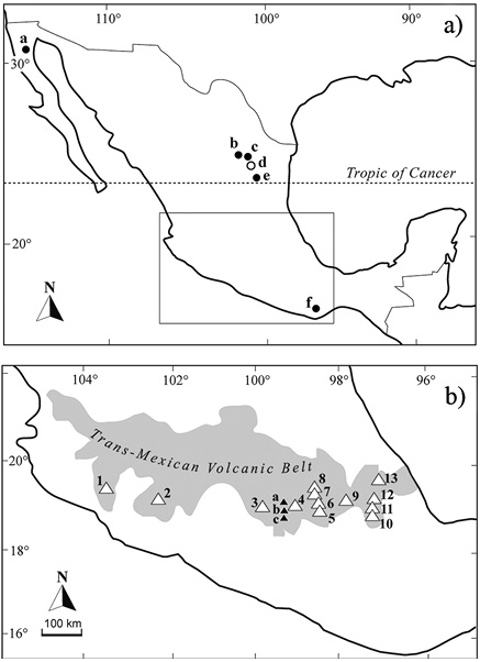
Figure 1. a) General location map showing mountains outside the Trans-Mexican Volcanic Belt with demonstrated glaciation (open circle) and probable glaciation (black circle): a. San Pedro Mártir (3000 m a.s.l.). b. La Viga (3700 m a.s.l). c. La Marta (3690 m a.s.l). d. Cerro Potosí (3720 m a.s.l). e. Peña Nevada-Pico San Onofre (3500-3550 m a.s.l). f. Quie Yelaag-Quiexobee (3700 m a.s.l). b) Location of mountains of the Trans-Mexican Volcanic Belt with evidence of late Pleistocene glaciation (open triangle) and probable mid Pleistocene glaciation (black triangle). The three highest mountains (underlined) supported glaciers in the early 21st century. 1. Nevado de Colima (4240 m a.s.l). 2. Tancítaro (3840 m a.s.l). 3. Nevado de Toluca (4650 m a.s.l). 4. Ajusco (3940 m a.s.l). 5. Popocatépetl (5450 m a.s.l). 6. Iztaccíhuatl (5220 m a.s.l). 7. Telapón (4060 m a.s.l). 8. Tláloc (4120 m a.s.l). 9. Malinche (4440 m a.s.l). 10. Sierra Negra (4580 m a.s.l). 11. Citlaltépetl (5650 m a.s.l). 12. Las Cumbres (3950 m a.s.l). 13. Cofre de Perote (4220 m a.s.l). a. San Miguel (3800 m a.s.l). b. Las Cruces (3700 m a.s.l). c. Zempoala (3690 m a.s.l).
Extent of Glaciation
In his pioneering study of modern glaciers in Mexico, Lorenzo (1964) listed eight volcanoes of the Trans-Mexican Volcanic Belt (TMVB) with traces of past glaciation: Nevado de Colima, Nevado de Toluca, Ajusco, Iztaccíhuatl, Popocatépetl, Malinche, Cofre de Perote, and Citlaltépetl. Heine (1975a) added Telapón and Tláloc to this list and two sites of northern Mexico with probable glaciation: Peña Nevada in Nuevo León and unidentified mountains in southern Durango.
To date, Late Pleistocene glaciation has been documented and mapped with different degree of detail on the following volcanoes of the TMVB (Figure 1), from west to east: Nevado de Colima (Lorenzo, 1961), Tancítaro (Vázquez-Selem, 2011), Nevado de Toluca (Heine, 1975a, 1994), Ajusco (White et al., 1990), Iztaccíhuatl (White, 1962, 1981b, 1987; Heine, 1975a, 1988; Vázquez-Selem and Heine, 2011), Popocatépetl (White, 1981a; Heine, 1975a, 1983; Espinasa-Pereña and Martin-del Pozzo, 2006), Malinche (Heine, 1975a, 1988), Citlaltépetl (Heine, 1975b, 1988) and Cofre de Perote (Vázquez-Selem, 2011; Carrasco-Núñez et al., 2010). Other mountains with clear traces of late Pleistocene glaciation yet to be studied are Tláloc, Telapón, Las Cumbres, and Sierra Negra (Figure 2). High mountains (higher than 4200 m a.s.l.) were glaciated during the early Holocene and the three highest ones (Citlaltépetl, Popocatépetl, Iztaccíhuatl) experienced significant glacier expansion in the late Holocene (Little Ice Age).
Geomorphological evidence (U-shaped valleys, cirque-like headwalls, narrow ridges or arêtes) suggests past glaciation in other mountains of the TMVB, but their lower elevation and more subdued morphology are indicative of glaciation prior to the Late Pleistocene. That is the case of three volcanic complexes near the SW corner of the Basin of Mexico: San Miguel (ca. 3800 m a.s.l.), Las Cruces (3700–3780 m a.s.l.), and Zempoala (3690 m a.s.l.; Figure 1b).
The record of glaciation has been partially obliterated on high mountains with persistent volcanic activity through the Late Pleistocene and Holocene, such as Citlaltépetl and Popocatépetl. Volcán de Fuego de Colima (3860 m a.s.l.) and Jocotitlán (3950 m a.s.l.) have elevations within the range of the Late Pleistocene snow lines of the region (3400–3950 m a.s.l., Lachniet and Vázquez Selem, 2005), but their Pleistocene-Holocene activity likely precluded the formation/preservation of glacial features. The same applies to Tacaná volcano (4060 m a.s.l.) in southeastern Mexico (Figure 1b).
In northern Mexico glaciation has been demonstrated only for Cerro Potosí (3720 m a.s.l.), the highest Mexican mountain to the north of the Tropic of Cancer (Vázquez-Selem and Heine, 2011). Observations on aerial photos and Google Earth imagery suggest that other peaks of Sierra Madre Oriental in the same area probably supported small glaciers in the late Pleistocene, but convincing field evidence is still missing. This is the case of Peña Nevada-Pico San Onofre (3500–3550 m a.s.l.) and especially the north-facing flanks of La Marta (3690 m a.s.l.) and La Viga (3700 m a.s.l.; Figure 1a).
No geomorphological evidence of past glaciers exists for the Sierra Madre Occidental. Even the highest peaks, located in southwestern and west Durango (3200–3300 m a.s.l.) likely did not surpass the Late Pleistocene regional snowline, which was probably close to the snowline of Tancítaro peak (ca. 3400 m a.s.l.). In northwest Mexico the best case for Pleistocene glaciation is Sierra de San Pedro Martir in Baja California, due to its high latitude (31° N) and elevation (2900–3000 m a.s.l.). Cirque glaciers probably formed around the highest peaks, but field evidence is still missing.
The highest peaks of Sierra Madre del Sur in Oaxaca (Quie Yelaag and Quiexobee), with an elevation of ca. 3700 m a.s.l., probably supported glaciers in the Late Pleistocene. However, their morphology as observed from air photos or satellite images is inconclusive.
In summary, glaciation during the Late Pleistocene (Marine Isotope Stage 2) was limited to the mountains of the TMVB, above 3800 m a.s.l., and to some peaks of the Sierra Madre Oriental, in NE Mexico, higher than 3600–3700 m a.s.l. Mountains of the TMVB peaking around 3700–3800 m a.s.l. show evidence of glaciation during a previous glacial cycle, presumably Marine Oxygen Isotope 6.
Timing of Glaciation
Since 1990 glacial geomorphology and chronology underwent a revolution with the development of cosmogenic nuclide dating (Granger et al., 2013). Prior to that time, the possibility of dating a glacial advance or recession depended mainly on maximum or minimum limiting dates associated with radiocarbon or tephrostratigraphy. Cosmogenic nuclide dating made it possible to directly date geomorphic surfaces produced by glaciers, such as moraine boulders or glacially abraded bedrock. In central Mexico, the volcanic origin of the rocks of the TMVB allows for the use of the cosmogenic dating method of Chlorine-36 (36Cl), a cosmogenic nuclide that does not require a specific mineralogy and that can be measured from whole rock (Phillips, 1995).
Iztaccíhuatl is the mountain with the longest record of glaciation in Mexico (White, 1987) due to its high elevation and its volcanic inactivity since ca. 80000 years BP (Nixon, 1989). The use of cosmogenic 36Cl (nearly 120 age determinations), in tandem with tephrostratigraphy and eight radiocarbon dates (14C), resulted in a glacial chronology of the last 200000 years BP (Vázquez-Selem, 2011). In addition, the application of 36Cl on Nevado de Toluca (Arce et al., 2003), Cofre de Perote (Carrasco-Núñez et al., 2010), and Tancítaro has allowed correlations of glacial deposits among different mountains, leading to a regional chronology (Vázquez-Selem and Heine, 2011). Figure 2 summarizes the glacial chronologies of different mountains in central Mexico and their correlation.
Overall, the main phases of glacial advance and moraine construction are related to cold events lasting several hundred to a few thousand years. Just as important from the paleoclimatic point of view are the phases of glacial retreat, produced by warming and in some cases drying conditions. From the LGM of the Late Pleistocene (26000–18000 years BP) through the early Holocene, the phases of glacial advance and retreat in central Mexico are overall synchronous to those of the northern tropics (Vázquez-Selem and Lachniet, 2017) and correlate well with the paleoenvironmental evolution of central Mexico (Caballero et al., 2010). Also, glacial advances are in general coeval to major cold events of the mid-latitudes of the northern hemisphere, namely the LGM, Heinrich event 1 (17000–15000 years BP), Younger Dryas (12900–117000 years BP) and the 8200 years BP cold event (Palacios et al., 2020).
However, major deglaciation in central Mexico did not start around 19000 years BP as in many other parts of the tropics and mid-latitudes, but rather after 15000 years, in coincidence with the Bolling-Allerod warm phase (14600–12900 years BP). The fact that glaciers on the highest mountains of central Mexico (> 5000 m a.s.l.) advanced during the Younger Dryas and the 9000–8000 years cold events, suggests that the northern tropics were substantially influenced by millennial-scale cooling phases of the mid and high latitudes of the Northern Hemisphere.
The most recent advance, recorded only on the three highest peaks of Mexico (> 5000 m a.s.l.), apparently is coeval to the Little Ice Age, a cold phase extending from ca. 1300 CE to ca. 1850 CE (Vázquez-Selem and Heine, 2011). However, 36Cl dating of the moraines is still pending.
Based on the reconstruction of former glaciers, estimates can be made of their equilibrium line altitude (ELA). The ELA is generally located around the 0 °C isotherm, whereby its position can be used to estimate paleotemperatures. Estimates of ELA depression and related cooling have been made for different glacial advances of Iztaccíhuatl mountain (Vázquez-Selem, 2011). During the maximum glacier extent of the Late Pleistocene (21000–17000 years BP), ELAs in central Mexico were at 3400–3950 m a.s.l., depending on the mountain, which implies an ELA depression of ca. 1600–1000 m with respect to the regional modern ELA of ca. 5000 m a.s.l. A similar range of ELA depression has been found in the mountains of northern tropical America during the LGM (Lachniet and Vázquez-Selem, 2005). This observation suggests a cooling of 6–9 °C during the LGM in central Mexico, which is in agreement with global cooling estimated from other proxies (e.g., Tierney et al., 2020).
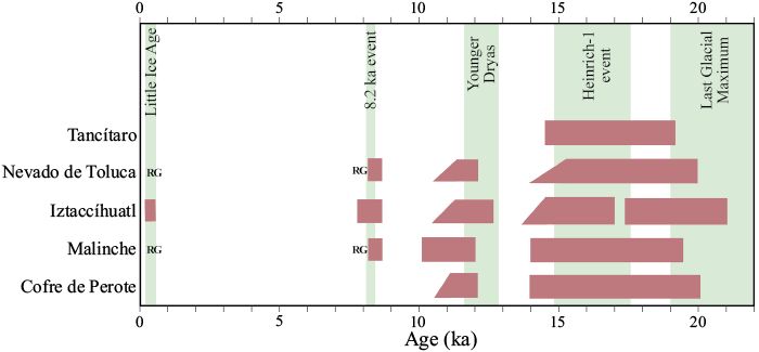
Figure 2. Correlation of glacial deposits of the mountains of central Mexico with global climatic events. Brown bars are glacial advances and moraine formation. RG: rock glacier formation. Green vertical bars are global climatic events. Ages for Iztaccíhuatl, Cofre de Perote, and Tancítaro mountains are based on cosmogenic 36Cl dating (Vázquez-Selem and Heine, 2011; Vázquez-Selem and Lachniet, 2017); ages for La Malinche and Nevado de Toluca mountains are in calendar years BP, originally reported as 14C years BP by Heine (1988).
CURRENT STATE OF MEXICAN GLACIERS
As mentioned in the previous section, glaciers in Mexico have been present in the highest mountains of Mexico for thousands of years: Iztaccíhuatl, Popocatépetl, and Citlaltépetl. As early as 1923, Weitzberg (1923) mentioned that "periodic oscillations", like those of the Popocatépetl glacier area, were observed in other glaciers of the world and that eruptive activity produced a slight decrease in glacier thickness. Robles-Ramos (1944) described the relationship of the Iztaccíhuatl glaciers with local meteorology. These ice bodies were studied for the first time between 1957 and 1958 during the International Geophysical Year. Lorenzo (1964) integrated the first Mexican glaciological inventory. White (1981a; 1981b) carried out studies on glacial fluctuations at Popocatépetl and Iztaccíhuatl volcanoes from the identification of existing and past equilibrium lines, estimating for the first time the magnitude of glacial retreat in Mexico. Later, Delgado-Granados (1997) presented an updated inventory of the glacieres of the Popocatépetl volcano based on field observations made between 1977 and 1992.
Glaciers of Iztaccíhuatl
Lorenzo (1964) measured the size of twelve glaciers using aerial photographs obtaining an extension of 1.4 km2 (revised by Cortés-Ramos and Delgado-Granados, 2015). Delgado-Granados et al. (1986) found that three of these glaciers were extinct and the rest were described and classified. Delgado-Granados et al. (2005) reported for 1982 a total glacier area of 0.97 km2, having lost an area of 20 % in 24 years. These authors studied one of the most representative glaciers of Iztaccíhuatl: the Ayoloco Glacier, reporting an area of 218340 m2 for 1982 and of 140890 m2 for 1998. Compared with the area reported by Lorenzo (1964), there is a 43 % glacier area loss in 40 years.
Schneider et al. (2008) updated the glacial inventory of Iztaccíhuatl volcano (Figure 3). The latter establishes a projection of the disappearance of these glaciers by 2020. Two years earlier, the Ayoloco glacier was declared extinct and only remnants of this glacier can be distinguished (https://www.dgcs.unam.mx/boletin/bdboletin/2021_349.html). At the time of this review, El Pecho is the only glacier remaining in this volcano which exceeds the projection proposed by Schneider et al. (2008). These authors clarified that although much of the glacial retreat is related to climate change, in situ observations suggest that geothermal heat fluxes and hydrothermal flows in the crater area should also be considered.
Thickness
Álvarez and Delgado-Granados (2002) studied the thickness of the La Panza glacier on Iztaccíhuatl using ground penetrating radar (GPR) to analyze the morphology of the ice substrate at depth and identified buried volcanic landforms as well. Subsequently, Delgado-Granados et al. (2005), used a maximum thickness of ~70 m, and an average thickness of ~20 m of the Ayoloco Glacier to estimate a glacial volume of 4516400 m3 (Figure 3).
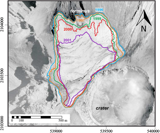
Figure 3. Recent changes in area size (1996-2001) in Popocatépetl Glaciers.
Glaciers of Popocatépetl
Lorenzo (1964) reported that the glacial area of Popocatépetl was 720000 m2 and consisted of three glaciers: North Glacier (190000 m2), Ventorrillo Glacier (435000 m2), and Northwest Glacier (120000 m2). Delgado-Granados et al. (1986) and Delgado-Granados (1997) pointed out that the North Glacier was part of the Ventorrillo Glacier because they share accumulation and drainage areas. The Ventorrillo Glacier had four glacier tongues (Tezcalco I and II, Ventorrillo, and Herradura) with two crevasse systems. The northwest glacier had no crevasse system of its own; most of it was made up of ice with a high detritus content, and although it shared an accumulation area with the Ventorrillo Glacier, it drained to the west. According to White (1954), maximum accumulation occurred from November to January, with an additional period from June to September, with snow being the main form of nourishment, followed by hail (from June to August), and re-frozen meltwater to a lesser extent. This was confirmed based on field observations by Delgado-Granados et al. (1986) and Delgado-Granados (1997).
Changes in Popocatépetl Glaciers
From 1958 to 1982, a decrease of 22 % in glacier extension was noted on the Popocatépetl mountain,, and from 1958 to 1996 the reduction in the area was 50 % (Delgado-Granados, 1996). Julio-Miranda et al. (2008) estimated that by February 2001, the remaining glacial area was only 29 % of that reported for 1958. The retreat of the altitude of the glacier front illustrates very well the disappearance of glaciers (Figure 4).
On December 21, 1994, an eruption began at Popocatépetl volcano characterized by volcanic explosions alternating with lava emissions. Julio-Miranda et al. (2008) established that phenomena associated with eruptive activity, such as the increase in heat flow under the glacial ice, the fall of tephra on its surface, and pyroclastic flows that moved over the glacier surface, caused its thinning, retreat and, in the final stage, its fragmentation between 1994-2001. The mass balance during the eruptive stage of Popocatépetl was estimated with ice loss of 81491 m3 (1996-1997), 1884292 m3 (1997-1999), and 1280639 m3 (1999-2000).
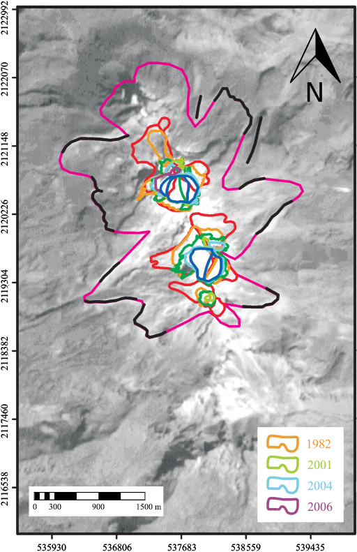
Figure 4. Recent changes in area size (1982-2006) in Iztaccíhuatl Glaciers.
Glaciers at Citlaltépetl
Lorenzo (1964) established the existence of nine glaciers covering an area of 9.5 km2, the largest glacial area in the country. Cortés-Ramos and Delgado-Granados (2015) corrected cartographic flaws and reconstructed the 1958 glacial area, reporting an extension of 2.04 km2. Cortés-Ramos and Delgado-Granados (2012; 2013) show that the Citlaltépetl glaciers were the largest contemporary ice bodies in the country. In 2007 they covered an area of 621230 m2, the north glacier had a maximum length of 960 m and reached a minimum altitude of 5126 m a.s.l. Volcanic activity is not as important as in Popocatépetl and Iztaccíhuatl, although Delgado-Granados (2007) mentions that the glaciers have retreated considerably, mainly due to climatic variations, despite low-temperature fumaroles near the summit of Citlaltépetl. This volcano is not surrounded by large cities as is the case of Popocatépetl and Iztaccíhuatl volcanoes.
Cortés-Ramos and Delgado-Granados (2012) established some relationships between glacial retreat and net radiation on the glacial surface of Citlaltépetl, indicating that there are areas more vulnerable than others to glacial retreat as those on the west slope of the volcano. Continuing in this line, Ontiveros-González et al. (2015) highlight the close relationship and dependence of the calculated energy balance over the glacier surface with the measured net radiation. Using data from an automatic weather station located over the glacier surface (5100 m a.s.l.), these authors observed (during three years of records) that the calculated surface energy balance over that location correlated better with net radiation than with sensible and latent heat fluxes. From this result, the authors suggested that net radiation is the main component responsible for glacier shrinkage since this parameter controls the energy balance variability.
Glacier retreat at Citlaltépetl
From 1958 (2.04 km2) to 1989 (1.29 km2), the area of Glaciar Norte glacier disappeared by 36 %, following a loss rate slower than that occurred during the period of 1989-1998 (-0.04 to 1 km2). After 2005, this loss rate declined ten times (-0.004 to 1 km2) compared to that calculated during the 1990s and the mid-twenties (Cortés-Ramos et al., 2019). By 2017, this glacier had lost 71 % of its area coverage relative to 1958 (Figure 5).
Geodetic measurements show retractions of the glacier front from the end of the LIA to the present. Between 1958 and 1989, the elevation of the glacier front changed at a rate of 3.7 to 1 m per year from, 4640 to 4755 m a.s.l. A drastic retreat in one of the glacier tongues took place during the 1990’s, separating this tongue from the main glacier body. The altitude of the glacier front changed from 4766 m a.s.l. in 1994 to 4965 m a.s.l. in 2017 when the accelerated retraction of the glacier had a maximum of +15 m per year during the period of 2005-2017. Cortés-Ramos and Delgado-Granados (2013) emphasized that the glacier front has moved steadily toward higher altitudes since 2001, similar to the global trend of glacier retreat (Zemp et al., 2007). Between 1990 and 2007, the glacier front rose ~100 m in altitude, corresponding with the disappearance of Jamapa and Chichimeco glacier tongues (Cortés-Ramos and Delgado-Granados, 2012; 2013).
Glacier depth
From a GPR profile conducted in 2006 (Ontiveros-González, 2018), a mean depth of ~19.5 m, a maximum of ~60 m, and a minimum approaching zero at the glacier edges were measured along the surface of the glacier. In 2016, a high-resolution GPR profile updated the maximum depth to ~80 m along a transverse transect at 5130 m a.s.l.
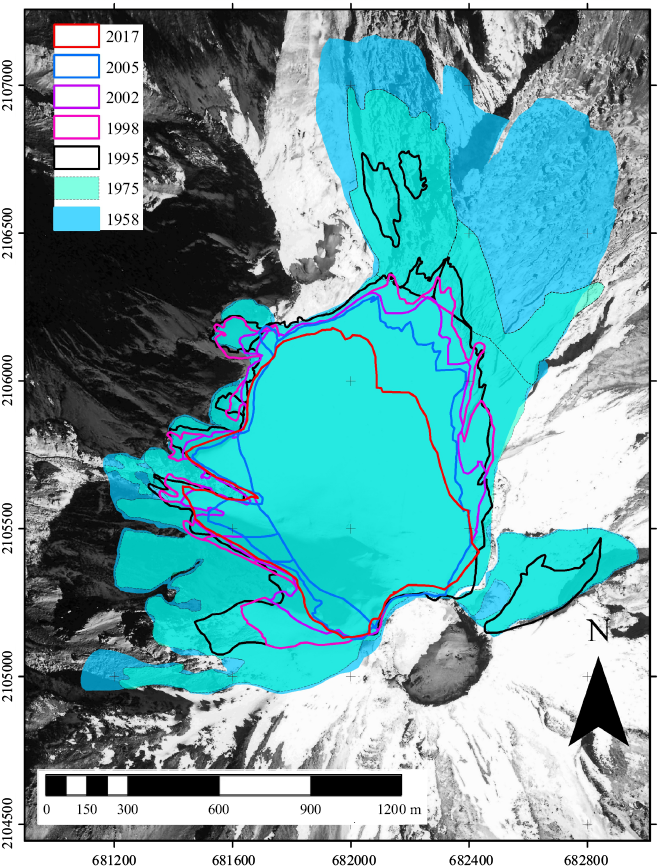
Figure 5. Recent changes in area size (1958-2017) in Citlaltépetl Glaciers.
Future prospects
Ontiveros-González (2018) proposed a projection for a possible scenario of the glacier volume evolution from 2016 based on an estimation of the glacier bed and the annual mass balance. In the proposed projection, between 2016 and 2020 the author expected a slight change over the depth found by the GPR profile and projected over the whole glacier, especially along the higher altitudes. Between 2021 and 2023, glacier thinning, and retraction is possible at the eastern and western edges, especially in the lower and middle elevations of the glacier surface. By 2023, the glacier bed will become visible around 5300 m a.s.l. By 2034 the glacier area will be reduced, representing 10 % of the area that was present in 2016. In 2038 or 2039, the glacier volume would be 10 % of the 2016 volume; then, the glacier surface will be fractionated into three parts. Finally, Ontiveros-González (2018) suggested that this fragmentation would mark the beginning of the glacier disappearance, leaving only small and scarce ice bodies above 5200 and 5300 m a.s.l.
According to Soto (2023), the accumulation zone of the Pico de Orizaba glacier system has not existed since 2019, which has caused the outcrop of the rock bed. Exposure of the bedrock increases solar energy transference as heat to the adjacent ice and snow, causing an increasing melting. At the same time, it prevents the flow of ice towards the ablation zone, causing an accelerated retreat of the glacier front. So, the current surface of the glacier is ~0.46 km2.
Periglacialism on Iztaccíhuatl
Andrés et al. (2010; 2011; 2012a; 2012b) emphasize the non-existence of continuous permafrost at Iztaccíhuatl due to the altitude of the volcano, recognizing the occurrence of isolated and discontinuous segments between 4600 and 5000 m a.s.l. Periglacial processes at Iztaccíhuatl volcano are based on soil thermal data and the presence of permafrost above 4900 m a.s.l. There are temperature records in Popocatépetl soils that allowed them to identify areas of discontinuous permafrost 200 m above the reported for Iztaccíhuatl. The air temperature at Iztaccíhuatl correlates with soil temperature data over a ten-year period, resulting in the periglacial zone of the volcano beginning at 4400 m a.s.l. with regions of discontinuous and isolated permafrost between 4600 and 5000 m a.s.l., depending on the orientation of the slopes.
Periglacialism on Popocatépetl
Delgado-Granados (1997) reported the existence of permanently frozen ground where landslides occurred due to hydric saturation or solifluxión. Delgado-Granados (1997) identified four areas of this type of soil in Popocatépetl: Norte (69000 m2), Yancuecole (43000 m2), Las Cruces (119000 m2) and Coyotes (8000 m2).
Periglacialism on Citlaltépetl
As early as 1975, the presence of fossil permafrost was reported between 4600 and 5000 m a.s.l. (Heine, 1975a), although it could begin above 4000 m a.s.l. when vegetation reaches its upper limit. He also mentioned that some terminal moraines above 4600 m a.s.l. could be rock glaciers. Based on air, soil, and glacier base temperature data, as well as on the correlation of insolation and albedo, together with documented critical elements, the lower limit of continuous permafrost has been documented at 4880 m a.s.l. and discontinuous permafrost above 4780 m a.s.l. on the northern slope of the volcano, as well as 4963 and 4863 m a.s.l. respectively on the southern slope. Due to the altitude of 4700 m a.s.l. of the glacial ice line until 1975 on the north face, the isolated portions of discontinuous permafrost must be the product of that glacial retreat (Soto-Molina et al., 2019). The possible existence of basal permafrost inside the main Citlaltépetl glacier can be suggested because the basement in the deepest part (115 meters) is preserved at -2.48 °C throughout the year without registering the minimum temperature oscillation. Seasonal temperature ranges influence the shallower parts without crossing the melting point barrier (Soto-Molina et al., 2019).
Recent studies (Soto-Molina and Delgado-Granados, 2020) indicate that periglacial activity at the Pico de Orizaba starts above 4584 m a.s.l., with the presence of cryoclasty that gives rise to the debris cones, sometimes flowing down. Additionally, at the northern slope, the lower limit of discontinuous permafrost is located at 4880 m a.s.l. and continues at 4963 m a.s.l.; while on the southern slope, both are located 100 m higher. More studies are needed on the Mexican cryospheric environment, particularly at the highest mountains of the country (e.g. the recent studies at Cofre de Perote volcano, which recreate the glacial cover and periglacial dynamics surface at the end of Late Pleistocene; Victor Soto, 2023, personal communication).
GLACIAL GEOCHEMISTRY
Snow precipitates together with micrometric solid particles (atmospheric aerosols) and gasses that accumulate in snow pores. Once precipitated in the glacier, the snow undergoes many physical (crystalline) changes forming ice of various types. Among the principals constituents of atmospheric aerosols precipitated in the snow, and accumulated (recorded) in glacial ice are: 1) Na, Cl, Mg, K, SO4 and many others elements, basically from marine source; 2) SiO2, Ca, Fe, Al, Mg, and many more elements from atmospheric dust; 3) C and heavy metals due to natural forest fires; 4) SiO2, Ca, Mg, Fe and many more compounds and elements derived from volcanic ash from local, regional and even global events (large volcanic explosions spew micrometer volcanic ash at high altitudes (10 to 20 km high) and can travel around the planet in a few weeks); 5) Fe, Ni, Pt and platinum-group elements and other metals derived from meteorite impacts; 6) all elements and compounds derived from human activity (industry, hydrocarbon burning, agriculture, pesticides, fertilizers, etc.); 6) atmospheric gasses (natural and anthropogenic gasses: O2, CO2, CH4, SO2, NO2, chlorofluorocarbons (CFC), etc.) that are trapped in ice pores during the crystalline transformation from snow to ice; and 7) cosmogenic elements (atmospheric cosmogenic isotopes which are formed due to cosmic ray impact with atoms of atmospheric gasses, e.g. 14C, 10Be, 36Cl, and others). In addition, precipitation temperature (summer precipitation-near 0 °C, or winter precipitation - temperatures from -10 to -60 °C, depending on latitude and altitude) can also be determined on the basis of stable isotopes of water (Deuterium and 18O). To this date (2023) there are also stable metal isotopic measuring techniques for several transition metals (i.e. Fe, Zn, Cu, Hg, Cd, Mo, Cr; Bullen, 2011). The ratio between a pair of stable metal isotopes allows us to relate isotopic fractionation with different geochemical processes and, ultimately, differentiate metal sources in the glacial record (natural or anthropogenic sources). In this section, we will discuss four techniques of glacial geochemistry: black carbon, metal geochemistry, stable isotopes of metals and atmospheric stable isotopes (10Be). These techniques are currently used to monitor climate-environmental records and anthropogenic impact, as well as the use of 10Be to relate climate change with solar activity variations.
Black Carbon
Black Carbon (BC) is an aerosol characteristic of the troposphere formed basically by the incomplete combustion of fossil fuels. The BC is taking great importance as a parameter to consider in the environmental climate impact of short time in glacial areas. Due to its light-absorbing properties, BC can darken the surface of snow or ice, affect the energy balance, and affect the melting rate of a glacier mass. Drilling, extraction, and analyses of glacial ice cores in different glaciers (continental and mountain) show a dramatic increase in BC since the 1850’s and continuously during the 20th and 21st centuries, consistent with fossil fuel-based industrial development. From 1970 onwards, a decrease in BC was detected in glacial areas of Europe and Antarctica and is assumed to be due to actions taken since the Clean Air Act. However, data from Himalayan glaciers show a continuous increase of BC in snow and ice. Because of its color, snow reflects most of the incident solar radiation. BC, like other solid materials, darkens the snow when deposited, decreasing the fraction of solar radiation reflected and increasing the solar radiation absorbed. In turn, more absorbed energy generally implies more melting of the glacier mass. Sources of black carbon are the burning of wood, carbon, and fuel oil, as well as other industry-related activities such as mining. This material can travel thousands of kilometers suspended in the air, so there is no region on earth where some amount of black carbon is not deposited, and its presence on glaciers is permanent, although its concentration may vary throughout the year. The retreat of glaciers cannot be explained by the presence of black carbon alone, but it is significantly related to climate change. There are several well-accepted methods for measuring the amount of black carbon deposited on snow surfaces. These methods have in common the sampling that is then passed through a filter for subsequent analysis by different techniques. One is the light-absorption heating method (LAHM) which is used to accurately quantify the impact of light-absorbing particles on snow (Schmitt et al., 2015). The premise behind this method is to estimate the amount of light energy that the particles will absorb that will cause increased melting or sublimation. Since snow is completely absorbing in the thermal infrared wavelength range, the most critical wavelengths to consider are in the visible range. The LAHM technique does not discriminate between BC and dust. Therefore, values derived from the LAHM technique should be treated as "effective black carbon" (eBC), which means that the visible light absorption capacity of the particles on the sample filter is equivalent to a given amount of BC. Figure 6 shows the average concentrations of black carbon for snow, glacier ice and high mountain lakes and springs from Iztaccíhuatl and Citlaltépetl, Mexico; Cordillera Blanca, Peru, and Cordillera Real, Bolivia, for 2019 and 2022 seasons. The BC measurements were carried out in the Laboratory of Environmental Geochemistry, Centro de Geociencias, UNAM. Bars indicate the averages of BC equivalent content (mg/kg) for all the sampling sites. The red square indicates the range of annual BC content as reported for samples from the Cordillera Blanca, Perú (Guillermo Ontiveros, 2023, personal communication; Schmitt et al., 2015).
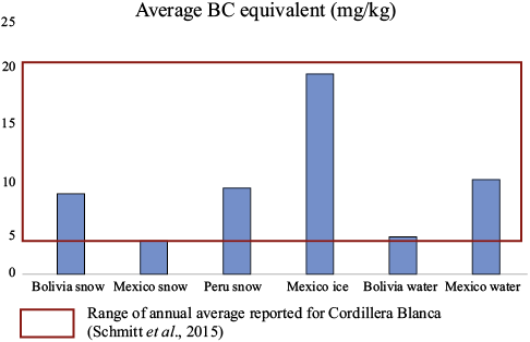
Figure 6. Average concentrations of black carbon (BC) for samples collected in the year 2022 and analyzed at the Laboratory of Environmental Geochemistry, Centro de Geociencias UNAM. Bars indicate the averages of BC equivalent content (mg/kg) for all the sampling sites. The red square indicates the range of annual BC content as reported for samples from the Cordillera Blanca, Perú (Schmitt et al., 2015).
Table 1. Summary of selected geochemical analyses for V, Cr, Ni, Cu, Zn, and Pb for Iztaccíhuatl and Citlaltépetl mountains during seasons of 2006 to 2021. Concentrations are in micrograms per liter (ppb). Carrilo-Chavez et al., 2023. Avg.: Average.
|
Year |
Location |
Sample/depth (cm) |
Altitude (m a.s.l.) |
V |
Cr |
Ni |
Cu |
Zn |
Pb |
|
2006 |
Iztaccíhuatl |
Snow (20) |
3500–4720 |
0.50 |
0.20 |
0.30 |
0.10 |
5.40 |
0.00 |
|
2007 |
Iztaccíhuatl |
Core (10–150) |
5100 |
0.50 |
1.00 |
7.50 |
2.89 |
39.12 |
0.35 |
|
2007 |
Citlaltépetl |
Core (10–150) |
5100 |
1.90 |
1.60 |
6.80 |
25.70 |
118.84 |
0.60 |
|
2008 |
Citlaltépetl |
Core (10–80) |
5100 |
0.60 |
0.50 |
5.58 |
4.64 |
38.24 |
0.31 |
|
2021 |
Citlaltépetl |
Core (10–100) |
5150 |
0.00 |
1.02 |
0.00 |
8.50 |
31.06 |
0.00 |
|
Avg. |
0.70 |
0.86 |
4.04 |
8.37 |
46.53 |
0.25 |
Heavy Metals
For about 6000 years, we have been using metals such as Cu, Fe, Zn, Au, Ag, and others, for our industrial and human society development. Since the Industrial Revolution (1700’s) we have considerably increased the number of metals we use in modern technology and industrial processes. But in the last 40 years, the number of metals used in modern technology has risen to around 68 (a good example of their use in modern technology is in our mobile devices, computers, electric cars, batteries, and other devices). On the other hand, some metals such as Ca, Mg, Fe, Cu, Co, Cr, Zn, Mo, Li (among others) are basic in the metabolic processes of plants, animals, and even humans. As mentioned above, these metals floating in the troposphere, as millimetric particles, are deposited in glacier snow and ice, forming an environmental record.
A very extensive database of heavy metals in ice cores has been obtained from Greenland, Antarctic, and Alpine snow and ice cores. But Lonnie Thompson and his team from Ohio State University, started drilling ice cores in the Peruvian Andes (tropical or low-latitude glaciers). They have gathered a geochemical database for nearly 40 years, dated 22000 BP (Last Glacial Maximum), to the Little Ice Age (1300 to 1850 CE). The most important conclusion of these works indicate that the metal source is mainly from rock and soil dust, but other sources are needed to be explained (Ferrari et al., 2001, Thompson, 2017). The current standard analysis of heavy metals in glacier ice and snow is carried out by using the sensitive ICP-MS technique, which can detect fractions of ppm. Ice cores in mountain glaciers have been drilled in the Andes, Alaska, Kilimankaro, Alps and Himalaya, but UNAM research is just starting to collect data of heavy metals in the small Mexican Glaciers. These glaciers are unique because they are the only ones at 19o north latitude in the world. Their geographical location, proximity to one of the largest metro areas in the world (Mexico City), industrial zones, and snow precipitation conducted by the convective patterns coming from the Gulf of Mexico and the Pacific Ocean, both in winter and summer storms, offers a good opportunity to analyse the anthropogenic impact on atmospheric precipitation recorded in glacier snow and ice. For the last decade, surface snow and glacier ice (borings and shallow cores at 1 m depth) have been sampled in Iztaccíhuatl and Citlaltépetl for geochemical and isotopic (Deuterium and 18O) analyses.
Considerable concentrations (micrograms/liter) of Zn, Cu, Fe, among other metals, and Nitrates have been detected. Table 1 shows a summary of the average concentrations of V, Cr, Ni, Cu, Zn, and Pb for Iztaccíhuatl and Citlaltépetl snow and ice above 5000 m for 15 years of sampling and monitoring metals in the glaciers (Carrillo-Chavez et al., 2023). Table 2 shows a comparison between the average metal content in a drill core of 120 m depth in Sajama Glacier, Bolivia (Ferrari et al., 2001) with the average metal content from the Mexican mountains (Carrillo-Chavez et al., 2023). V, Cr, and Pb are an order of magnitude greater in Mexican mountains with respect to data for Sajama, Bolivia. Zn and Cu concentrations are up to three orders of magnitude higher in Mexican glaciers. These higher concentrations in snow and ice from Mexican glaciers with respect to Sajama have several possible explanations: 1) The core samples from Sajama are of much greater depth and represent much older ages (22000 yr BP for the 120 m depth; 8000 yr BP for 100 m depth; 1650 CE for the 60 m depth and 1897 CE for the 40 m depth (Ferrari et al., 2001). In fact, the samples for depths 120, 100 and 80 m, could be taken as base values due to natural sources (dust, ashes from fires, volcanic ashes, and other natural sources). The 40 m depth data (1987 CE) show a slight increase for the elements V, Cu, Zn, Pb and may be due to an increase in industrial activity in Bolivia or the area around. On the other hand, 1) the Iztaccíhuatl and Citlaltépetl samples are from the period between 2006 and 2021, and represent the great industrial activity in central Mexico; 2) the proximity of Mexican glaciers to important industrial areas (oil, automotive, metal-mechanical) and to one of the largest metropolitan areas in the world (Mexico City) may explain these higher concentrations; and 3) the Popocatépetl volcano is very close to Iztaccíhuatl (15 km) and not far from Citlaltépetl (142 km away). Popocatépetl has been intermittently active since 1994 with periodic eruptions of gasses, ash, and other volcanic material. Volcanic ash eruption (material with trace metals) and circulation in the upper troposphere easily allow the accumulation of ash metals in the snow and glacial ice of the high mountains of Mexico.
Stable Metals Isotopes
Traditional environmental stable isotopes have been used for several decades (Deuterium, 18O, 13C, 15N and 34S). However, with technological advances in mass spectrometry during the last 20 years, the isotopic system of transition metals has been investigated to understand important issues such as tracking sources and fates of metal contaminants and the development of geochemical and biogeochemical isotopic signatures. In general, stable isotopes of metals in the environmental samples (water, soil, organic matter, snow-glacial ice) contain valuable information about the sources of metals (natural or anthropogenic) and the geochemical processes that have affected the samples. We will focus only on four of the stable isotopes of transition metals that are currently used for signatures in the environment, and their application in glacial geochemistry: Zn, Cu, Fe, and Hg.
Zinc (Zn)
Zinc is an element widely used in modern industry, from alloys, fertilizer, paints, electronics, and other industrial and technological uses. Zn is also an important trace element essential in plant, animal, and human metabolic processes. Zn has five stable isotopes 64Zn (48.63 % natural abundance), 66Zn (27.90 %), 67Zn (4.10 %), 68Zn (18.75 %), and 70Zn (0.62 %). The most commonly used isotopic ratio is 66Zn/64Zn which in geological materials varies approximately 2 ‰. Variations in the 66Zn/64Zn ratio (isotopic fractionation) are a good indicator of geochemical processes and sources of Zn to the environment. Figure 7 shows a comparison of isotopic composition (range of δ66/64Zn ) for ZnS (sphalerite ore), Zn in sediments of mine tailings, Zn in anthropogenic materials, Zn in hydrothermal vent fluids, Zn in seawater and the first preliminary published (δ66/64Zn) data for snow and glacier water from Iztaccíhuatl and Citlatepetl, Mexico, and Cordillera Blanca, Peru (Sivry et al., 2008; (Bermin et al., 2006; John et al., 2007, 2008; Sivry et al., 2008; Black et al., 2011). The first preliminary published (δ66/64Zn) data for snow and glacier water from Iztaccíhuatl and Citlatepetl, Mexico, and Cordillera Blanca, Peru (Calvo-Ramos et al., 2023) also are included in the comparison of Figure 7. The samples from Iztaccíhuatl (Izta Panza 220704), Citlaltépetl (CA-2 and Agua Piedra Grande), and Cordillera Blanca (5/Peru) seem to be related to natural sources (atmospheric dust). However, sample CA-1 (Citlaltépetl) seems to be related to an anthropogenic source (possible micro-particles from hydrocarbon combustion). More δ66/64Zn data for snow and ice samples from high mountains in Mexico and Peru are being processed for publication, which will allow a better understanding of the natural vs. anthropogenic source (Alejandro Carrillo-Chavez, personal communication, 2023).
Copper (Cu)
Copper was one of the first metals to be used by humans (along with Au and Ag). Today Cu has many industrial applications: electrical wires, electronics, metal alloys, paint, pipes, and in coins. Cu is part of a relatively small group of metallic elements that are essential for human health. Copper and other metals are necessary for normal metabolic processes. Thus, the human diet must supply regular amounts for their absorption. Cu has two stable isotopes: 63Cu (69.17 % natural abundance) and 65Cu (30.83 %). In natural materials, the measured range of 65Cu/63Cu is about 9 ‰ for solid samples and 3 ‰ for water samples (Larson et al., 2003; Borrok et al., 2008). The microbe Acidithiobacillus ferrooxidans has been documented to be partly responsible for copper fractionation (Mathur et al., 2005). Novak et al., 2016, used Cu and Zn stable isotopic fractionation (δ65Cu and δ66Zn) to fingerprint sources and dispersion pathways of pollutants in the air using snow from Central Europe.
Table 2. Comparison between the average metal content in a drill core of 120 m depth in Sajama Glacier, Bolivia (Ferrari et al., 2001) with the average metal content from the Mexican mountains (Carrillo-Chavez et al., 2023). Concentrations are in micrograms per liter (ppb). See the text for details and possible explanations of the differences.
|
Metal |
Sajama 120 m |
Sajama 100 m |
Sajama 60 m |
Sajama 40 m |
Iztaccíhuatl Surface |
Citlaltépetl Surface |
|
V |
0.06 |
0.15 |
0.071 |
0.10 |
0.50 |
0.83 |
|
Cr |
0.03 |
0.05 |
0.01 |
0.02 |
0.60 |
1.04 |
|
Ni |
n/r |
n/r |
n/r |
n/r |
3.90 |
4.13 |
|
Cu |
0.09 |
0.24 |
0.06 |
0.15 |
0.15 |
12.95 |
|
Zn |
0.27 |
0.23 |
0.21 |
0.38 |
22.26 |
62.71 |
|
Pb |
0.03 |
0.09 |
0.06 |
0.36 |
0.18 |
0.30 |
Mercury (Hg)
Mercury was widely used in thermometers and other scientific devices, amalgams for dental restorations, Hg vapor lamps, cosmetics, and liquid mirror telescopes. Historically, Hg has been widely used in gold mining operations. Today, because of its toxicity, the use of mercury is banned in most countries of the world, but its presence in the environment is still considerable. Mercury and its compounds (e.g., monomethyl mercury (MeHg) and mercuric chloride) are extremely toxic and can be easily ingested by inhalation or absorption through the skin and mucous membranes. Mercury has seven stable isotopes: 196Hg (0.15 % natural abundance), 198Hg (9.97 %), 199Hg (16.87 %), 200Hg (23.10 %), 201Hg (13.18 %), 202Hg (29.86 %), and 204Hg (6.87 %). The measured range of 202Hg/198Hg in natural materials resulting from mass-dependent fractionation (MDF) between coexisting Hg groups is approximately 7 ‰. In addition, the stable isotopes of Hg exhibit considerable mass-independent fractionation (MIF), in which the odd isotopes 199Hg and 201Hg behave differently from the even isotopes in certain chemical reactions such as photochemical reduction (Bergquist and Blum 2007; Blum, 2011), leading to significant enrichments and depletions of the odd isotopes relative to the even isotopes in environmental Hg reservoirs. Blum (2011) notes that most environmental applications of Hg isotopes are related to (1) interpretation of the isotopic composition of MeHg present in sediments and organisms, or (2) interpretation of the isotopic composition of Hg(II) associated with sediments or deposited on the land surface or in a water body. Zheng et al. (2021) used Hg stable isotopes to reveal the sources of atmospheric Hg in the high artic (snow precipitation during the polar spring from 2011 to 2015.
Cosmogenic Isotopes (10Be)
10Be is not a stable berillyum isotope, rather it is a cosmogenic Be isotope formed when cosmic rays (high-energy neutrons and protons from astronomical sources) collide atmospheric O2 and N2 molecules and trigger a series of nuclear reactions (spallation processes). The most useful Be isotopes for use in geosciences are the short-lived 7Be (half-life 53.1 days) and the longer-lived 10Be (half-life 1.4 Ma; Nishiizumi et al., 2007). Because the cosmic rays that cause the initial cascade of neutrons and protons in the upper atmosphere responsible for the spallation reactions are attenuated by the mass of the atmosphere itself, cosmogenic Be production rates are three orders of magnitude higher in the stratosphere than at sea level (Masarik and Beer 1999, 2009). Therefore, most of the cosmogenic Be production takes place in the upper atmosphere (5–30 km). Once cosmogenic Be forms in the atmosphere, it precipitates in rain, snow, hail, and dry deposition. Cosmogenic Be production rates vary inversely with solar activity because increased solar output strengthens the Earth’s magnetic field which acts as a shield and deflects cosmic rays. On timescales of decades, production rates vary by approximately 25 % with the 11-year solar cycle, but over the course of hundreds of years, production rates can vary by a factor of two or more due to longer timescale cycles in the sun activity (Koch and Mann, 1996; Vonmoos et al., 2006). As cosmic rays are deflected poleward, cosmogenic Be production rates are a factor of three to five higher in polar air than in equatorial air (Harvey and Matthews, 1989; Masarik and Beer, 1999), depending on altitude. Thus, polar atmospheres have higher amounts of cosmogenic Be, but precipitation rates are generally very low. The strong gradient of cosmogenic Be production with atmospheric elevation causes seasonal variability (at least in some latitude belts) in 7Be and 10Be deposition. This has been evident in midlatitudes, as injections of stratospheric air into the troposphere during the spring of each year result in higher concentrations of cosmogenic Be in meteoric waters (Husain et al., 1977). Snow usually has higher cosmogenic Be isotope concentrations than rain, possibly due to the larger surface area of snowflakes compared to raindrops, and to the higher production of cosmogenic Be at higher altitudes in the atmosphere (McNeary and Baskaran, 2003). The nearly constant production rate of cosmogenic Be isotopes in the atmosphere (Leya et al., 2001; Vonmoos et al., 2006) and the reactive nature of Be atom particles (You et al., 1989) make meteoric cosmogenic Be nuclides a valuable tracer of a wide range of chemical, physical, meteorological, and solar activity variation processes, which are recorded in continental and mountain glacier ice sheets over time periods ranging from tens of years to hundreds of thousands of years. These data, complemented with other climatic and environmental records at local, regional, and global levels, provide valuable information on the climatic variations of the Earth over the indicated time span.
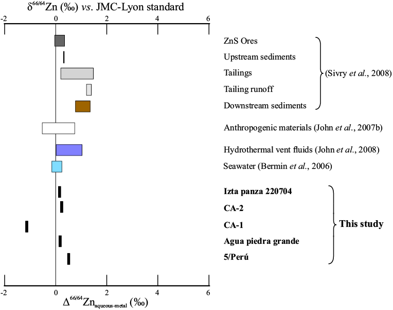
Figure 7. Comparison of isotopic composition (range of δ66/64Zn) for different natural sources of Zn (Sivry et al., 2008; John et al., 2007a; Bermin et al., 2006), a compilation of anthropogenic materials (John et al., 2007), and the first preliminary published (δ66/64Zn) data for snow and glacier water from Iztaccíhuatl and Citlatepetl, Mexico, and Cordillera Blanca, Peru (Calvo-Ramos et al., 2023). Modified from Black et al., 2011. See texts for discussion.
CONCLUSIONS
Glaciers have shaped the highest mountains of central Mexico throughout the Late Quaternary (22000 BP to 2023 CE). In the last decades, UNAM-based research on past and modern glaciers has provided valuable information on glacier chronology for the last 20000 years, The glacier changes during the last 73 years are reported in detail, and their chemistry (environmental pollution) during the last 17 years also is reported.
The reconstruction of glacier change at millennial time scales requires the use of state-of-the-art dating techniques, namely cosmogenic nuclide dating. This has allowed for the development of robust chronologies and thereby correlations between the glacial records and other proxies of climate and environmental change (local, regional, and global) from the Last Glacial Maximum to the Little Ice Age.
Monitoring modern glaciers on the three highest mountains of Mexico since the middle of the 20th century has been one of the most important sources of information on the impact of climate change on tropical mountains. The analyses of glacier area, thickness, and elevational change have shown the close linkages between climate warming and glacier dynamics on some of the last glaciers of the northern tropics.
Using glacier ice as an archive, geochemical analyses on these lingering glaciers aim to provide valuable data on environmental change and anthropic disturbance for the last few decades.
ACKNOWLEDGMENTS
We would like to express our gratitude to the "Grupo Geoquímica Montañismo UNAM” for the help and support in sampling and ice core drilling in Citlaltépetl and Iztaccíhuatl glaciers: Jaime Carrera, Dora Carreón, Erandi Cerca, Gabriela Ponce "Gaby", Lorenzo Ortíz "Lencho", Juan Carlos Gómez de la Fuente "Jano", Samael Oliver "Sama", Javier Cortés Rosas, Julio Zacatzi, Daniela Montaño "Dany", Jehú Hinojosa, Eber Ramirez "Gerber", Jonatán Hortelano "Jona", Libertad Barrón, Luis Acosta and Raúl Gómez for all his hard work, companionship and friendship. The current work on "Glacier Geochemistry" is possible thanks to the resources of the UNAM-PAPIIT IN110421 Project "Concentrations and Isotopic fractionation of Zn and Hg in rainwater and high mountain glacial ice: geochemical processes, sources and trajectories of metals in central México" to Alejandro Carrillo-Chavez. The pionner work on Zn stable isotopes in Centro de Geociencias UNAM was possible to Project UNAM-PAPIIT IN108315 and PASPA-DGAPA, UNAM Grant for a sabbatical year (January 2017 to January 2018) to Alejandro Carrillo-Chávez. Research on the glacial chronology was supported by UNAM-PAPIIT grant IN110223 to Lorenzo Vázquez-Selem. Hugo Delgado Granados acknowledges the support of the PASPA-DGAPA, UNAM during his sabbatical leave which allows the opportunity to publish. Collaboration with colleagues at LMU was possible thanks to the Alexander von Humboldt Foundation. Jorge Cortes Ramos thanks to CONACYT and CICESE-Unidad La Paz for the Program “Investigadores por México” with Project Number 497. Daniela Kristel Calvo-Ramos thanks to CONAHCyT for her PostDoc Grant (2022-2023). Finally, we would like to express our deep appreciation to Joaquín Canchola "Don Canchola" and all his lovely family from Tlachichuca (Summit Orizaba), and to Roberto Flores Rodríguez "El Oso" and all his wonderful crew from San Miguel Zoapan (Orizaba Mountain Guides), Puebla, for their many years of transportation, meals, lodging support, and long-lasting friendship and companionship during the fieldwork.
REFERENCES
Álvarez, R., Delgado-Granados, H., 2002, Characterization of a tropical ice body on Iztaccíhuatl volcano, México, in Koppenjan S.K., Lee H. (eds.), Ninth International Conference on Ground Penetrating Radar: - Proceeding of SPIE, 4758, 438-442.
Andrés, N., Palacios, D., Zamorano, J., Vázquez-Selem, L. 2010, Distribución del permafrost e intensidad de los procesos periglaciares en el estratovolcán Iztaccíhuatl (México): Ería, 83, 291-310.
Andrés, N., Palacios, D., Zamorano, J., Vázquez-Selem, L., 2011, Shallow ground temperatures and periglacial processes on Iztaccíhuatl volcano, México. Permafrost and Periglacial Processes, 22 (2), 188-194.
Andrés, N., Palacios, D., Zamorano, J., Mendoza-Margáin, C., Vázquez-Selem, L., 2012a, Diez años de control térmico en el suelo del estratovolcán tropical Iztaccíhuatl (México), in XII Reunión Nacional de Geomorfología: Santander, España, Sociedad Española de Geomorfología, 649-652.
Andrés, N., Palacios, D., Zamorano, J., Mendoza-Margáin, C., Vázquez-Selem, L., 2012b, Temperatura del suelo en el volcán Popocatépetl: Implicaciones entre actividad volcánica y deglaciación, in VIII Reunión Nacional de Geomorfología, Guadalajara, Jal., México, Sociedad Mexicana de Geomorfología, 25-26.
Arce, J.L., Macías, J.L., Vázquez-Selem, L., 2003, The 10.5 ka Plinian eruption of Nevado de Toluca volcano, Mexico: Stratigraphy and hazard implications: Geological Society of America Bulletin, 115(2), 230-248.
Bergquist, B.A., Blum, J.D., 2007, Mass-dependent and independent fractionation of Hg isotopes by photoreduction in aquatic systems: Science, 318, 417-420.
Bermin J., Vance D., Archer C., Statham P.J., 2006, The determination of the isotopic composition of Cu and Zn in seawater: Chemical Geology 226, 280-297.
Black, J.R., Kavner, A., Schauble, E.A., 2011, Calculation of equilibrium stable isotope partition function ratios for aqueous zinc complexes and metallic zinc: Geochimica et Cosmochimica Acta, 75(3), 769-783.
Blum, J.D., 2011, Applications of stable mercury isotopes to bio-geochemistry, in Baskaran, M. (ed), Handbook of Environmental Isotope Geochemistry, Advances in Isotope Geochemistry: USA, Springer, 944 pp.
Böse, E., Ordóñez, E., 1901, Der Iztaccíhuatl (5,280 m). Eine Berg und Gletscherfahrt in den Tropen: Zeitschrift des Deutschen und Österreichischen Alpenvereins, 32, 138-158.
Borrok, D.M., Nimick, D.A., Wanty, R.B., Ridley, W.I., 2008, Isotopic variations of dissolved copper and zinc in stream waters affected by historical mining: Geochimica et Cosmochimica Acta, 72(2), 329-344.
Bullen, T., 2011, Stable Isotopes of Transition and Post-Transition Metals as Tracers in Environmental Studies, in Baskaran, M. (ed.), Handbook of Environmental Isotope Geochemistry, Advances in Isotope Geochemistry: USA, Springer, 944 pp.
Caballero, M., Lozano-García, S., Vázquez-Selem, L., Ortega, B., 2010, Evidencias de cambio climático y ambiental en registros glaciales y en cuencas lacustres del centro de México durante el Último Máximo Glacial: Boletín de la Sociedad Geológica Mexicana 62, 359-377.
Calvo-Ramos, D., Pribil, M., García, R., Muñoz-Torres, C., Carrillo-Chávez, A. 2023, Isótopos estables de zinc y su uso como trazadores en el medio ambiente de nieve de alta montaña en México (Iztaccíhuatl y pico de Orizaba), in Resúmenes Convención Geológica Nacional, Cd. De México, México, Sociedad Geológica Mexicana.
Carrasco-Núñez, G., Siebert, L., Díaz-Castellón, R., Vázquez-Selem, L., Capra, L., 2010, Evolution and hazards of a long-quiescent compound shield-like volcano: Cofre de Perote, Eastern Trans-Mexican Volcanic Belt: Journal of Volcanology and Geothermal Research, 197(1-4), 209-224.
Carrillo-Chavez A., Calvo-Ramos D.K., Muñoz-Torres C., García R., 2023, Geoquímica Glaciar: Registro Climático Ambiental que se pierde: Enseñanza y Comunicación de las Geociencias, 2(1), 10-15.
Cortés-Ramos, J., Delgado Granados, H., 2012, The recent retreat of Mexican glaciers on Citlaltépetl Volcano detected using ASTER data: The Cryosphere Discussions, 6(4), 3149-3176, doi:10.5194/tcd-6-3149-2012.
Cortés-Ramos, J., Delgado Granados, H., 2013, La evolución del mayor glaciar de México: vista desde el espacio: Mexico, City, Mexico, Coordinación de Estudios de Posgrado, Universidad Nacional Autónoma de México, 148 pp. ISBN: 978-607-02-4731-6. (Sitio web: http://www.posgrado.unam.mx/publicaciones/ant_col-posg/).
Cortés-Ramos, J., Delgado-Granados, H., 2015, Reconstruction of glacier area on Citlaltépetl volcano, 1958 and implications for México’s deglaciation rates: Geofísica Internacional, 54(2), 111-125.
Cortés-Ramos, J., Delgado-Granados, H., Huggel, C., Ontiveros-González, G., 2019, Evolution of the largest glacier in Mexico (Glaciar Norte) since the 50s: Factors driving glacier retreat: Geografiska Annaler: Series A, Physical Geography, 101(4), 350-373.
De Terra, H., Romero, J., Stewart, T.D., 1949, Tepexpan Man: New York, Publications in Anthropology, 11, Viking Fund., 160 pp.
Delgado-Granados, H., 1996, Los glaciares del Popocatépetl: ¿huéspedes efímeros de la montaña?: Ciencias, 41, enero-marzo, 24-32.
Delgado-Granados, H., 1997, The glaciers of Popocatépetl volcano (México): Changes and causes: Quaternary International, 43/44, 53-60.
Delgado-Granados, H., Arciniega, R., Calvario, D., 1986, Estudios glaciológicos en los volcanes Popocatépetl e Iztaccíhuatl, in Resúmenes de la Convención Nacional, Sociedad Geológica de México: Mexico City, Mexico, 109 pp.
Delgado-Granados, H., Julio-Miranda, P., Álvarez, R., Cabral-Cano, E., Cárdenas-González, L., Correa-Mora, F., Luna Alonso, M., Huggel, C., 2005, Study of Ayoloco glaciar at Iztaccíhuatl volcano (México): hazards related to volcanic activity-ice cover interactions: Zeitschriftfür Geomorphologie, 140, 181-193.
Delgado-Granados, H., Julio-Miranda, P., Huggel, C., Ortega del Valle, S., Alatorre-Ibargüengoitia, M.A., 2007, Chronicle of a death foretold: Extinction of the small-size tropical glaciers of Popocatépetl volcano (México): Global and Planetary Change, 56, 13-22.
Espinasa-Pereña, R., Martín-Del Pozzo A.L., 2006, Morphostratigraphic evolution of Popocatépetl volcano, México, in Siebe, C., Macías, J.L., Aguirre-Díaz G.J. (eds.), Neogene-Quaternary continental margin volcanism: A perspective from México: Boulder, CO, USA, Penrose Conference Series, Geological Society of America Special Paper 402, 115-137.
Ferrari, C.P., Clotteau, T., Thompson, L., Barbante, C., Cozzi, G., Cescon, P., Hong, S., Maurice-Bourgoin, L., Francou, B., Boutron, C., 2001, Heavy metals in ancient tropical ice: initial results: Atmospheric Environment, 35, 5809-5815.
Granger, D.E., Lifton, N.A., Willenbring, J.K., 2013, A cosmic trip: 25 years of cosmogenic nuclides in geology: Geological Society of America Bulletin, 125(9-10), 1379-1402.
Harvey M.J., Matthews, K.M., 1989, 7Be deposition in a high-rainfall area of New Zealand: Journal of Atmospheric Chemistry, 8, 299-306.
Heine, K., 1975a, Permafrost am Citlaltépetl/Mexiko: Eiszeitalter u. Gegenwart, 26, 212-217.
Heine, K., 1975b, Studien zur jünquartären Glazialmorphologie mexikanischer Vulkane. Mit einem Ausblick auf die Klimaentwicklung. Das Mexiko Projekt der Deutschen Forschungsgemeinschaft, VII: Franz Steiner, Wiesbaden, 178 pp.
Heine, K., 1983, Mesoformen der Periglazialstufe der semihumiden Randtropen, dargestellt an Beispilen der Cordillera Neovolcánica, Méxiko: Abh. Akademie der Wissenschaften in Göttingen, Mathematisch-Physicalische Klasse, Series III, 35, 403-424.
Heine, K., 1988, Late Quaternary glacial chronology of the Mexican volcanoes: Die Geowissenschaften, 7, 197-205.
Heine, K., 1994, Present and past geocryogenic processes in México: Permafrost and Periglacial Processes, 5, 1-12.
Heine, K., 2019, Das Quartär in den Tropen. Eine Rekonstruktion des Paläoklimas: Springer-Verlang, Germany, 735 pp.
Husain, L., Coffey, P.E., Meyers, R.E., Cederwall, R.T., 1977, Ozone transport from stratosphere to troposphere: Geophysical Research Letters, 4(9), 363-365.
Imbrie, J., Imbrie K.P., 1979, Ice Ages. Solving the mystery: Cambridge University Press, Cambridge, 224 pp.
John S.G., Park J.G., Zhang Z., Boyle E.A., 2007, The isotopic composition of some common forms of anthropogenic zinc: Chemical Geology, 245, 61-69.
John S.G., Rouxel O.J., Craddock P.R., Engwall A.M., Boyle E.A., 2008, Zinc stable isotopes in seafloor hydrothermal vent fluids and chimneys: Earth and Planetary Science Letters 269, 17-28.
Julio-Miranda, P., Delgado Granados, H., Huggel, C., Kääb, A., 2008, Impact of the eruptive activity on glacier evolution at Popocatépetl volcano (México) during 1994-2001: Journal of Volcanology and Geothermal Research, 170, 86-98.
Koch, D.M., Mann, M.E., 1996, Spatial and temporal variability of 7Be surface concentrations. Tellus B: Chemical and Physical Meteorology, 48(3), 387-396.
Lachniet, M.S., Vazquez-Selem, L., 2005, Last Glacial Maximum equilibrium line altitudes in the circum-Caribbean (México, Guatemala, Costa Rica, Colombia, and Venezuela): Quaternary International, 138-139,129-144.
Lachniet, M.S., Asmerom, Y., Bernal, J.P., Polyak, V.J., Vazquez-Selem, L., 2013, Orbital pacing and ocean circulation-induced collapses of the Mesoamerican monsoon over the past 22 000 yr. Proceedings of the National Academy of Sciences, 110, 9255-9260.
Larson, P.B., Maher, K., Ramos, F.C., Chang, Z., Gaspar, M., Meinert, L. D., 2003, Copper isotope ratios in magmatic and hydrothermal ore-forming environments. Chemical Geology, 201(3-4), 337-350.
Leya, I., Neumann, S., Wieler, R., Michel, R., 2001, The production of cosmogenic nuclides by galactic cosmic‐ray particles for 2π exposure geometries: Meteoritics & Planetary Science, 36(11), 1547-1561.
Lorenzo, J.L., 1961, Notas sobre la geología glacial del Nevado de Colima: Boletín del Instituto de Geología, 61, 77-92.
Lorenzo, J.L., 1964, Los glaciares de México: , México, Instituto de Geofísica, Universidad Nacional Autónoma de México, 2a. edición, 124 pp.
Lozano-García, S., Vázquez-Selem, L., 2005, A high elevation Holocene pollen record from Iztaccíhuatl volcano, central México: The Holocene 15, 329-338.
McNeary, D., Baskaran, M., 2003, Depositional characteristics of 7Be and 210Pb in southeastern Michigan: Journal of Geophysical Research: Atmospheres, 108(D7).
Masarik, J., Beer, J., 1999, Simulation of particle fluxes and cosmogenic nuclide production in the Earth’s atmosphere: Journal of Geophysical Research: Atmospheres, 104, 12099-12111.
Masarik, J., Beer, J., 2009, An updated simulation of particle fluxes and cosmogenic nuclide production in the Earth’s atmosphere: Journal of Geophysical Research: Atmospheres, 114(D11).
Mathur, R, Ruiz J, Titley S, Liermann L, Buss H, Brantley, S.L., 2005, Cu isotopic fractionation in the supergene environment with and without bacteria. Geochim Cosmochim Acta, 69, 5233–5246.
Nishiizumi, K., Imamura, M., Caffee, M.W., Southon, J.R., Finkel, R.C., McAninch, J., 2007, Absolute calibration of 10Be AMS standards: Nuclear Instruments and Methods in Physics Research Section B, 258(2), 403-413.
Nixon, G.T., 1989, The Geology of Iztaccíhuatl volcano and adjacent areas of the Sierra Nevada and Valley of México: Boulder, The Geological Society of America, Special Paper 219, 58 pp.
Novak, M., Sipkova, A., Chrastny, V., Stepanova, M., Voldrichova, P., Veselovsky, F., Krachler, M., 2016, Cu-Zn isotope constraints on the provenance of air pollution in Central Europe: Using soluble and insoluble particles in snow and rime: Environmental Pollution, 218, 1135-1146.
Ontiveros González, G., 2018, Estudios de la dinámica glacial del "glaciar norte" del volcán Citlaltépetl:, Universidad Nacional Autónoma de México, Programa de Posgrado en Ciencias de la Tierra, Ph.D. Thesis, 148 pp.
Ontiveros-González, G., Delgado-Granados, H., Cortés-Ramos, J., 2015, Surface Energy Balance model for high-altitude glacial system at 19 N on Glaciar Norte, México: Geofísica Internacional, 54(4), 299-314.
Palacios, D., Stokes, C.R., Phillips, F.M., Clague, J.J., Alcalá-Reygosa, J., Andrés, N., Angel, I., Blard, P.-H., Briner, J.P., Hall, B.L., Dahms, D., Hein, A.S., Jomelli, V., Mark, B.G., Martini, M.A., Moreno, P., Riedel, J., Sagredo, E., Stansell, N.D., Vázquez-Selem, L., Vuille, M., Ward, D.J., 2020, The deglaciation of the Americas during the Last Glacial Termination: Earth-Science Reviews, 203(103113), 1-58.
Phillips, F.M., 1995, Cosmogenic chlorine-36 accumulation: A method for dating Quaternary landforms. in Rutter N.W., Catto, N.R. (eds.), Dating methods for Quaternary deposits: Ottawa, Canada, Geological Association of Canada, 61-66.
Robles-Ramos, R., 1944, Algunas ideas sobre la glaciología y morfología del Iztaccíhuatl: Revista Geográfica, 4(10/11/12), 65-98.
Schmitt, C,G., All, J.D., Schwarz J.P., Arnott, W.P., Cole, R.J., Lapham, E,, Celestian, A., 2015, Measurements of light-absorbing particles on the glaciers in the Cordillera Blanca, Peru: The Cryosphere, 9(1), 331-340.
Schneider, D., Delgado Granados, H., Huggel, C., Kääb, A., 2008, Assessing lahars from ice-capped volcanoes using ASTER satellite data, the SRTM DTM and two different flow models: case study on Iztaccíhuatl (Central México): Natural hazards and Earth system sciences, (8), 559-571.
Sivry, Y., Riotte, J., Sonke, J.E., Audry S., Schafer, J., Viers, J., Blanc, G., Freydier, R., Dupre, B., 2008, Zn isotopes as tracers of anthropogenic pollution from Zn-ore smelters The Riou Mort-Lot River system: Chemical Geology, 255, 295-304.
Soto, V., 2023, Bedrock outcropping in the accumulation zone of the largest glacier in Mexico (Glaciar Norte of Citlaltépetl), as evidence of a possible accelerated extinction: Journal of Mountain Science 20, 338-354, https://doi.org/10.1007/s11629-021-7216-2.
Soto-Molina, V., Delgado-Granados, H., Ontiveros-González, G., 2019, Estimación de la temperatura basal del “Glaciar Norte” del volcán Citlaltépetl, México. Modelo para determinar la presencia de permafrost subglacial: Estudios Geográficos, 80(287), e019.
Soto-Molina, V., Delgado-Granados, H., 2020, Distribution and current status of permafrost in the highest volcano in North America: Citlaltépetl (Pico de Orizaba), México: Geofísica Internacional, 59(1), 39-53, https://doi.org/10.22201/igeof.00167169p.2020.59.1.2079.
Tierney, J.E., Zhu, J., King, J., Malevich, S.B., Hakim, G.J., Poulsen, C.J., 2020, Glacial cooling and climate sensitivity revisited: Nature, 584(7822), 569-573.
Thompson, L., 2017, Past, Present, and Future of Glacier Archives from World’s Highest Mountains: Proceedings of the American Philosophical Society, 161(3), 226-243.
Vázquez-Selem, L., 2011, Las glaciaciones en las montañas del centro de México, in Caballero, M., Ortega Guerrero, B. (eds.), Escenarios de cambio climático: registros del Cuaternario de América Latina I: Mexico City, Mexico, Universidad Nacional Autónoma de México, 215-238.
Vázquez-Selem, L., Heine, K., 2011, Late Quaternary Glaciation in México, in Ehlers, J., Gibbard P.L., Hughes P.D. (eds.), Quaternary Glaciations - Extent and Chronology. A closer look: Amsterdam, Elsevier, 849-861.
Vázquez-Selem, L., Lachniet, M.S., 2017, The deglaciation of the mountains of México and Central America: Cuadernos de Investigación Geográfica 43, 553-570.
Vonmoos, M., Beer, J., Muscheler, R., 2006, Large variations in Holocene solar activity: Constraints from 10Be in the Greenland Ice Core Project ice core: Journal of Geophysical Research: Space Physics, 111(A10).
Weitzberg, W., 1923, El ventisquero del Popocatépetl: Mexico City, Mexico, Memoria Sociedad Científica A. Alzate, 41, 65-90
White, S.E., 1954, The Firn Field on the Volcano Popocatépetl, México: Journal of Glaciology, 2, 389-392.
White, S.E., 1962, El Iztaccíhuatl. Acontecimientos volcánicos y geomorfológicos en el lado oeste durante el Pleistoceno Superior: Mexico City, Mexico, Instituto Nacional de Antropología e Historia, Serie Investigaciones, 6, 80 pp.
White, S.E., 1981a, Equilibrium line altitudes of late Pleistocene and recent glaciers in Central México: Geografiska Annaler, 63A, 241-249.
White, S.E., 1981b, Neoglacial to recent glacier fluctuations on the volcano Popocatépetl, México: Journal of Glaciology, 27, 357-361.
White, S.E., 1987, Quaternary glacial stratigraphy and chronology of México: Quaternary Science Reviews, 5(1-4), 201-205.
White, S.E., Reyes-Cortes, M., Ortega Ramírez, J., Valastro, S., 1990, El Ajusco: geomorfología volcánica y acontecimientos glaciales durante el Pleistoceno superior y comparación con las series glaciales mexicanas y las de las Montañas Rocallosas: Mexico City, Mexico, Instituto Nacional de Antropología e Historia, 212 pp.
You, C.F., Lee, T., Li, Y.H.,1989, The partition of Be between soil and water: Chemical Geology, 77(2), 105-118.
Zemp, M., Haeberli, W., Bajracharya, S., Chinn, T.J., Fountain, A.G., Hagen, J.O., Karki, M., 2007, Glaciers and ice caps. Part I: Global overview and outlook, Part II: Glacier changes around the world. Global outlook for ice and snow: Nairobi, United Nations Environment Programme, 115-152.
Zheng, W., Chandan, P., Steffen, A., Stupple, G., De Vera, J., Mitchell, C. P., Bergquist, B.A., 2021, Mercury stable isotopes reveal the sources and transformations of atmospheric Hg in the high Arctic. Applied Geochemistry, 131, 105002.
>